4. Sultan IIIc2 - Early Bronze IIIB
(2450-2300 BC)
 The general layout of the city was preserved in
Sultan IIIc2, when, following a violent destruction, Jericho was
fully rebuilt. The double city-walls were investigated in Area B
and
B West, at the south-western
corner of the city. The Inner Wall (W.1),
both in Area B and B West, resulted to have
been repaired in various
spots,
while the
Outer Wall (W.51)
had been moved inwards and
rebuilt with a thickness of 3.0 m .
On the southern side of the fortifications, excavations in
Area B exposed Building B1, a structure erected against the Inner
City-Wall.
The general layout of the city was preserved in
Sultan IIIc2, when, following a violent destruction, Jericho was
fully rebuilt. The double city-walls were investigated in Area B
and
B West, at the south-western
corner of the city. The Inner Wall (W.1),
both in Area B and B West, resulted to have
been repaired in various
spots,
while the
Outer Wall (W.51)
had been moved inwards and
rebuilt with a thickness of 3.0 m .
On the southern side of the fortifications, excavations in
Area B exposed Building B1, a structure erected against the Inner
City-Wall.
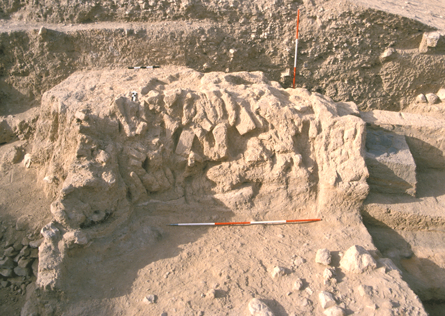 The building included a row of
rectangular rooms (L.38, L.39, L.539), parallel to the city-wall, and a
main
The building included a row of
rectangular rooms (L.38, L.39, L.539), parallel to the city-wall, and a
main east-west wall
(W.34+W.534), delimitating a courtyard. Even if, due to erosion and
previous excavations, these rooms were only partially preserved,
finds suggest that they was devoted to food production: three limestone mortars where found in L.39, while L.38 was characterized
by the presence of a hearth in
a
corner, paved with basalt stones
and reemployed grinders.
east-west wall
(W.34+W.534), delimitating a courtyard. Even if, due to erosion and
previous excavations, these rooms were only partially preserved,
finds suggest that they was devoted to food production: three limestone mortars where found in L.39, while L.38 was characterized
by the presence of a hearth in
a
corner, paved with basalt stones
and reemployed grinders.
The
plan, the number of rooms, the thickness of walls and their
building technique, suggest that Building B1 had
a
public
function, 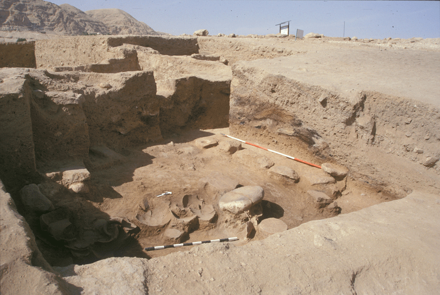 hosting extra-familiar food production.
Building B1 was destroyed by a violent
earthquake, as
it is shown by its
main wall ruinously
hosting extra-familiar food production.
Building B1 was destroyed by a violent
earthquake, as
it is shown by its
main wall ruinously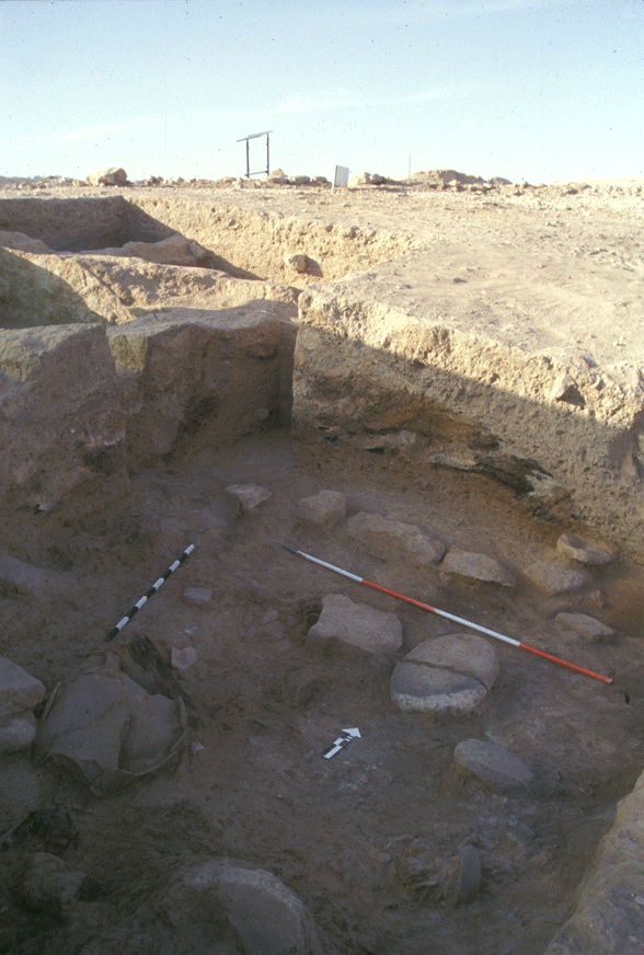 collapsed,
and it is also visible in cracks and subsided sections of the
nearby city-walls . Calibrated radiocarbon dates allow to fix
this event around 2350 BC. Successively, the area was
re-occupied by the same inhabitants for some decades. Then, the
site was definitively abandoned.
collapsed,
and it is also visible in cracks and subsided sections of the
nearby city-walls . Calibrated radiocarbon dates allow to fix
this event around 2350 BC. Successively, the area was
re-occupied by the same inhabitants for some decades. Then, the
site was definitively abandoned.
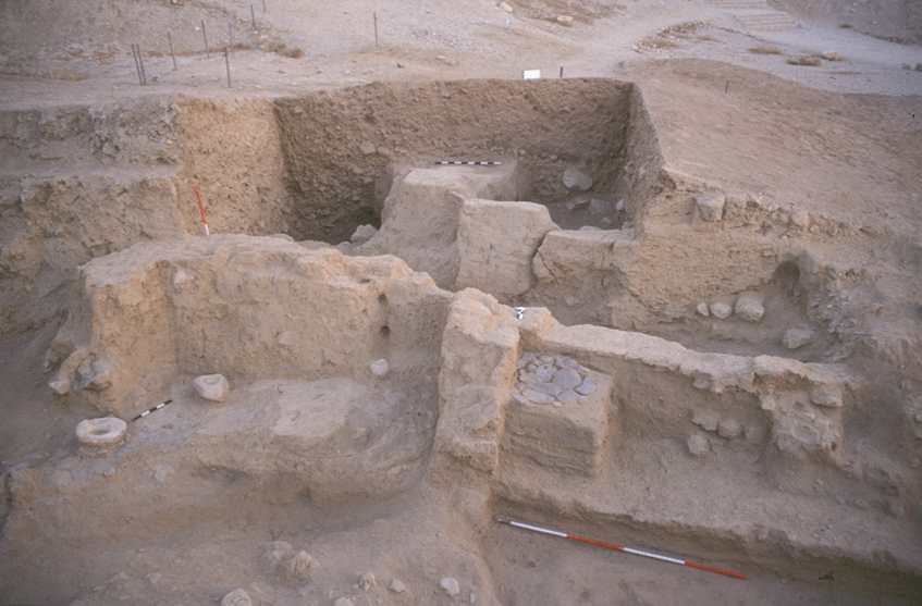
Further insights within public architecture and
history of Tell es-Sultan during Period IIIc2 (EB IIIB) were
provided by excavations in Area G, on the
preserved top of the
Spring Hill. Here, a major building (Building G1) was discovered, after the removal of extensive pits (F.601 and
F.603) from the Byzantine period, with 1.0 m thick plastered walls, showing a
size and a plan markedly different from that of  contemporary
domestic architecture. Three rooms of Building G1 were fully exposed
(L.620, L.644 and L.961), with thick mud-brick walls, showing a line
lime revetment, and a series of modelled installations. In the smallest room (L.620) a plastered bin was present along the north wall (B.618), probably for working with liquid substances. The main room to the east (L.644) was destroyed by a fierce fire and the roof
collapsed all together, as testified to by the carbonized wooden beams, fallen
over the floo
contemporary
domestic architecture. Three rooms of Building G1 were fully exposed
(L.620, L.644 and L.961), with thick mud-brick walls, showing a line
lime revetment, and a series of modelled installations. In the smallest room (L.620) a plastered bin was present along the north wall (B.618), probably for working with liquid substances. The main room to the east (L.644) was destroyed by a fierce fire and the roof
collapsed all together, as testified to by the carbonized wooden beams, fallen
over the floo r and found still parallel one to
the other.
r and found still parallel one to
the other.
Six large storage jars were found in this room
proving that it was also devoted to
storage, being at the same time
employed
for transformation of food, as attested to by flint blades, flat
stones used as working surfaces, benches
(B.640 and
B.645), and series of clay bins.
A third room to the east (L.961), aligned with
the previous ones, was identified only in its southern wall (W.616),
which confirms a certain degree of monumentality for the building:
its scale, its location and the wealth of archaeological finds
suggest that it had a public function.
After its destruction, due to the earthquake
already noticed in Area B, which occurred towards the end of Period
IIIc2 (around 2350 BC), Building G1 was rebuilt in a less monumental
way, and then definitely abandoned around 2300 BC.