|
TELL ES-SULTAN/JERICHO � ARIHA (Palestinian National Authority)Preliminary Report on the 6th Season of Archaeological Investigations and Restorations at Tell es-Sultan/Jericho by Rome �La Sapienza� University and the Palestinian MOTA-DACH � March 2010
Lorenzo Nigro - Hamdan Taha
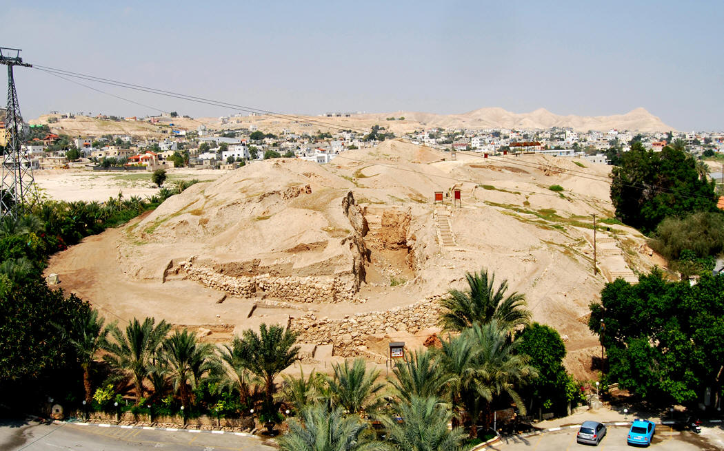
0. IntroductionRome �La Sapienza� University and the Palestinian Department of Antiquities and Cultural Heritage (MOTA - DACH) carried out the sixth season of archaeological activities at Tell es-Sultan, ancient Jericho (fig. 1), in March 2010, with the financial support of the Italian Ministry of Foreign Affairs: The main goal of the joint expedition was to pursue the full rehabilitation of the site through archaeological investigations, monuments and finds restoration, and tourist valorization. The Action Plan for this seasons was aimed at the following objectives: 1. tourist valorization through paths, areas fences, brochure for visitors, refurbishing of the entrance and the shelter on the Spring Hill, and explanatory panels at the major areas on the site (� 1); 2. site rehabilitation and presentation, through systematic restorations of the Sultan IIIc2 (EB IIIB) public building in Area G, and a stretch of the Sultan IIIc1 (EB IIIA) Inner City-Wall in Area Q, on the western side of the tell (� 2); 3. archaeological investigations in four areas: Area A, with Sultan IVa-b (MB I-II) Building A1, Sultan IVb (MB II) houses and Sultan IVc (MB III) Cyclopean Wall and rampart at the southern foot of the tell, (� 3); Area B, with the Sultan IIIc1 (EB IIIA) double fortification line and city-gate at the southern edge of the tell, on top of Kenyon�s Trench III (� 4); Area E, with the Sultan IVb (MB II) stone defensive structure on the south-western flank of the site (� 5); Area G, with the Sultan IIIc2 (EB IIIB) public building on the eastern flank of the Spring Hill (� 6). The above mentioned goals were achieved with the help of local workers, public and private institutions, and several interesting discoveries increased our knowledge on this multi-stratified site, spanning from the Pre-Pottery Neolithic Period to the Bronze Age (10th-2nd millennium BC) and later periods.
1. Rehabilitation of the site through tourist valorizationOne main goal of the Pilot Project is the full rehabilitation of Tell es-Sultan as the core of a Palestinian National Archaeological Park of the Jericho Oasis. To pursue such goal, an articulated tourist path has been studied including sixteen monuments, each illustrating a period of life of the ancient city. Explanatory panels with Arabic and English legends (fig. 2) � not ideologically oriented �, pictures of finds, plans and reconstructions, were set up at selected spots of the site, while a brochure is distributed at the entrance, showing the same key spots for reading the history of Tell es-Sultan (fig. 3). Four new panels were installed in the sixth season: a general panel in Arabic at the entrance; a panel at the view point on the east side of Trench III and Area B; one panel in Area G; and another one at Kenyon�s Site M. Moreover, the main entrance to the site and the shelter on the top of the Spring Hill, from which a wide panorama over the Oasis and the underlying Spring is watchable, have been fully refurbished (fig. 4).
2. Restorations: EB IIIA Building G1 and City-Wall in Area QSystematic restorations of excavated monuments are � of course � a necessary corollary of the Pilot Project of valorization of the site, and, in the sixth season (2010), the public building of Area G on the Spring Hill was chosen for such an intervention. Works started from room L.620, at the westernmost limit of the excavated portion of the building (fig. 5). It was refurbished according to traditional techniques of earthen architecture already experimented in Areas B and F, which together with reversibility offer a soft impact on monuments, and allow to preserve the general look of mudbrick structures and installations, making them readable for general public. A second intervention was carried out in Area Q, opened in season 2009 on the western side of the tell, looking Jebel Quruntul, just south of Kenyon�s Trench I and Site D (Nigro - Taha 2009, � 5), where the EB IIIA Inner City-Wall and postern were restored with a top course of mudbricks intended as protective upper stratum. Also the stone foundations of these structures were reinforced and protected.
3. Area A: Sultan IVa-b (MB I-II) Building A1, Sultan IVb (MB II) houses and Sultan IVc (MB III) Cyclopean Wall and rampartArea A (fig. 6) was further expanded towards the west including squares AqIV13, ApIV13 and ApIV12; moreover, the 9 x 4 m trench opened in year 2000 in squares AmIV12+AnIV12 was also resumed. Furthermore, a deep sounding at the foot of Cyclopean Wall W.4 down to Pre-Pottery Neolithic strata was dug in square ApIV12/AqIV12. 3.1. Sultan IVa-b (MB I-II) Tower A1The exploration of Tower A1 (fig. 7), started in 1997 (Marchetti - Nigro 1998, 124-135; 2000, 199-207; Nigro 2006a, 26, 33; Nigro - Taha 2009, � 2), was completed during the sixth season (2010), bringing to light the monumental western stone foundation of the building (W.1659), consisting of a row of orthostates, supporting the massive mudbrick superstructure 1.6 m wide, made of regular reddish-brown mudbricks, preserved up to 2.4 m (fig. 8). The area west of Tower A1, possibly an inner courtyard or a passageway, has been fully excavated, fixing its western limit and reconstructing its stratigraphy and history (fig. 9). Building A1 was erected during Middle Bronze I (Sultan IVa) after an overall regularization of the southern foot of the tell (with Early Bronze I, II, IV and Neolithic residual material). After a certain while, illustrated by a single floor level (L.1670, 1690), at the end of Middle Bronze I, it suffered a fierce destruction, which left three superimposed layers of ashes, limestone scales, and burnt bricks over the floor. Also the tower was damaged, and it was restored at the beginning of Middle Bronze II (Sultan IVb), by adding emboldening walls all around its stone foundations (and a transversal wall to the north: W.22; Marchetti - Nigro 1998, 134-135, figs. 4:15, 4:17; 2000, 194-195, 207, figs. 5:7, 5:24, 5:26). Inside the tower, the original floor was raised and the stone basement for the wooden staircase descending into it was apparently eliminated (the ground floor of the tower was perhaps filled up; Marchetti - Nigro 2000, 194, 199-200, figs. 5:15-5:16). Repaired Tower A1, thus, remained in use during Middle Bronze II (Sultan IVb), being surrounded by houses growing up against it (Marchetti - Nigro 2000, 194-195, 207-216; Nigro 2006a, 33). Roughly 15 m west of Tower A1, another Middle Bronze II (Sultan IVb) private house (House A4) was uncovered in the western trench AmIV12+AnIV12 (fig. 10), showing that the building did not extend so far. Here a clay figurine of a quadruped animal painted in matt red (fig. 11) was found, together with a limestone pommel of a dagger, carefully refined (fig. 12). Middle Bronze II (Sultan IVb) life in Area A lasted more than a century (1800-1650 BC): a first destruction left a layer of ashes and chops over the earliest MB II flooring (L.1660, L.1680); this destruction was then razed and regularized by a new flooring set up over it (this was the lowest layer reached in season 1999: L.500), until another destruction occurred, leaving heaps of mudbricks on the ground. With erection of the third rampart supported by Cyclopean Wall W.4 at the beginning of Middle Bronze III (Sultan IVc; Marchetti - Nigro 1998, 135-154; 2000, 217-218; Nigro 2006a, 34-35), the southern quarter of Middle Bronze Jericho, including Building A1 and the surrounding houses, was abandoned and the whole area was buried under layers of rubble (fig. 6). The foot of MB III (Sultan IVc) Cyclopean Wall W.4 was reached in the deep sounding opened in square ApIV12/AqIV12 (see below � 3.2). The lowest layer within the foundation trench of this monumental structure was filled up with a bed of medium size stones, upon which the first boulders of the Cyclopean Wall were laid. 3.2. Deep sounding down to Pre-Pottery Neolithic B (7500-6000 BC) strataA deep sounding enlarging the foundation trench of Cyclopean Wall W.4 (fig. 13) was excavated with the aim of checking upon which layers both Building A1 and the latter structure were erected. Immediately underneath a leveling layer (F.1761), which represents the MB I (Sultan IVa) regularization of the foot of the tell for the erection of Building A1, a series of Pre-Pottery Neolithic surfaces were excavated, all of them dating back to Pre-Pottery Neolithic B (Sultan Ic, 7500-6000 BC). They mainly consist of yellowish sandy layers with pebbles and limestone scales, sometimes covered by silt accumulation with ashes and charcoals. A limestone adze (fig. 14) and the fragment of a human skull are the most relevant finds from these layers, which attest to the extension to the south of the PPNB settlement.
4. Area B: the Sultan IIIc1 (EB IIIA) South Gate across the double line of fortificationsDuring rehabilitation works in Area B, on top of Kenyon�s Trench III across the EB III (Sultan IIIc) double line of fortifications (Marchetti - Nigro 1998, 23-24, 32-33, figs. 1:1, 1:15, 81-94; Nigro 2006a, 9, 18; 2006b, 361-375), in the same area where in 1997-1999 EB IIIB Building B1 was uncovered and restored (Marchetti - Nigro 1998, 39-49; 2000, 130-138; Nigro 2006a, 18-20), a major opening was identified through the EB IIIA (Sultan IIIc1) main Inner City-Wall (Wall 2; Marchetti - Nigro 1998, 36-39, fig. 1.1, 81-94; Nigro - Taha 2009, � 4)), later concealed by the EB IIIB (Sultan IIIc2) reconstruction of the same defensive structure (Wall 1; Marchetti - Nigro 1998, 36-39, figs. 1:1, 1:15). The gate (L.1800), 2 m wide and 4.5 m long, was blocked by walls on the outer and inner sides (the latter nowadays eroded), while, inside it, collapsed mudbricks covered two carbonized wooden beams, possibly belonged to the lintel/roofing of the inner passageway (fig. 15). It introduced into a sort of corridor in between the Inner and Outer Walls, approached from the east (a transversal wall, excavated by Kenyon [Kenyon�s wall NFF], blocked the passage towards the west in between the two city-walls; Kenyon 1981, pl. 269c). The South Gate, thus, probably consisted of a bent-axis entrance exploiting for a stretch the gap inside the double-line fortification. It was obliterated at the end of Sultan IIIc1 (EB IIIA) period, when a new city-gate was opened elsewhere (possibly to the east near the Spring).
5. Area E: the Sultan IVb (MB II) Curvilinear Stone Structure, and underlying Sultan IIIb-d (EB I, II, IV) strata on the south-western-flank of the tellExcavations in Area E, on the south-western slope of the tell (Marchetti - Nigro 2000, 181-192; Nigro 2006a, 29-30), allowed to bring to light for a length of almost 40 m a massive stone structure, built up with juxtaposed walls running all around the flank of tell, and slightly climbing it SE-NW (fig. 16). This defensive device, interrupting the MB II rampart, was named Curvilinear Stone Structure, and attributed to Middle Bronze II (Sultan IVb), basing on material found both outside it (abutting on, and cut through by it) and inside it (where a destruction layer and the underlying floor were reached). Roughly at the mid of the excavated stretch of the CSS, a rectangular (7.5 x 2.1 m) bastion (Buttress W.270) protruded, apparently to strengthen it at the south-western corner of the site. In correspondence of the easternmost stretch of the structure, in the space facing Wall 5 and Wall 560, a low battering wall (W.1703) run parallel to them, bordering to the north a street (L.1725) running SE-NW (fig. 17). In between border wall W.1703 and the CSS, a rectangular unit (L.1706), excavated in 2009, represented the latest occupational layer of Middle Bronze II (Sultan IVb). It covered another mudbricks structure (W.1715), a stratum of collapsed mudbricks related to it (F.1713), and a layer of collapse (F.1712), which represents the regularization of the berm on the southern flank of the site upon which the Middle Bronze II (Sultan IVb) CSS was erected. The latter filling concealed an EB IVB (Sultan IIId2) wall (W.1734; fig. 18), and, underneath it, the corner of an EB II (Sultan IIIb) house (fig. 19), with a wall (W.1739) flanked by a bench (W.1744) and a floor (L.1720), which yielded some diagnostic sherds, such as a local Abydos Ware-like fragment and the neck of a swollen rim white-coated jar. Both structures were cut through by the foundation trench (P.1723) of the CSS at the beginning of Middle Bronze II, filled up with crushed mudbricks (F.1742). Finally, a careful examination of the latter has shown some interesting features: the reinforced corner of Wall 5 to east (fig. 19), suggesting the presence of a passage, and the collapse just aside Buttress W.270, with a kind of reinforcing foot or reparation (W.1741) at the bottom. What seems noteworthy in this part of the CSS is the distinction in the central stretch between Wall 5 and Buttress W.270 of a section thinner (1.1 m) than the other part of the structure (1.3-1.7 m). South of border wall W.1703, the lowest layer (F.1743) reached so far dates back to Early Bronze IB (Sultan IIIb), as a Line-Painted bowl found in it may indicate (fig. 20; Nigro 2005). It was cut through to the south by the foundation trench of Cyclopean Wall W.4 (P.1729), which was filled up with reddish-brown mudbricks (F.1731).
6. Area G: the Sultan IIIc2 (EB IIIB) public Building B1 on the Spring HillArchaeological investigations in Area G, on the eastern flank of the Spring Hill, were resumed after eleven years with the aim of completing the exploration of public Building G1 (fig. 21; Marchetti 2003, 300-303, fig. 4; Nigro 2006a, 20-22, figs. 29-32; 2009a, 50, fig. 6), which was interrupted in year 2000, and of starting an overall restoration of this monument. The area was, thus, expanded northwards, including square BcIII7, in which the north-eastern corner of room L.644 was concealed (eastern wall W.637 + northern wall W.1161). A long deal was spent in the uncovering of at least fifteen wooden beams buried in the collapse/destruction layer F.1158 on the northern side of this room, just over rectangular podium B.645 (fig. 22). The latter installation was lined with square stones and had at its southern corners two round stones with a circular hollow in the middle (respectively a mortar and a door socket). Both devices may have been reemployed as bases of wooden posts for a light roofing covering the podium. Along the eastern side of the room a small circular stone-lined hearth and a circular plastered platform were uncovered. In this spot, in 1999, a row of collapsed jars was excavated, which were fully restored in the 2010 campaign (figs. 23-24). On the southern side of the room, near the SW corner, a blocked door (L.1150) was identified, still with white plaster on its doorjambs, belonging to the original layout of the building. Door L.615, on the western side, facing B.645, was, thus, a secondary entrance, as it is also shown by the elevation of its threshold. This detail allows to clarify the two stages of use attested to in room L.644, with blocked door L.1150 contemporary to square mastaba B.640, a feature present only in the latest utilization of the room. East of door L.1150, a shallow bench (B.1169) lined the southern wall W.616 up to the SE corner of the room. On the opposite NE corner, another small bench (B.1167) flanked podium B.645, and possibly served as step to enter it. The completion of excavation of the collapse layer in the room allowed to expose the original floor in the whole space and to collect several finds, including four complete storage jars (TS.99.G.337/1, TS.99.G.337/7, TS.99.G.341/5, TS.99.G.339/6), one metallic pattern-combed white-coated jar (TS.99.G.342/1), and one pattern-combed hole-mouth jar (TS.99.G.339/12), as well as one hole-mouth pot (TS.99.G.339/3), and several fragments of at least overall 12 jars. Objects and tools found in room L.644 (fig. 23) thoroughly illustrate Sultan IIIc2 (EB IIIB) material culture (2 pierced shells, 1 stopper, 1 token, 1 spindle whorl, 3 flint blades, 1 grinder, 1 grinding stone, and 1 working base). An utmost find from this room is a pottery sherd with a cylinder seal impression showing two decorated registers (TS.10.G.100): in the upper one, a lion catching a gazelle in front of a tree is visible, while in the lower one a man with a bow and an arrow follows some birds and a fish. The orientation of the two registers is bustrophedic. This seal impression recalls that already known from three sherds found by the Austro-German Expedition in 1907-1909 in the same area (Sellin - Watzinger 1913, fig. 66), and attests to a certain control of valuable goods production in EB IIIB Jericho, as well as the concentration of such products in Building G1. North of L.644, excavation brought to light a small square room (L.1160; 2.2 x 2.2 m), with a semicircular slab-paved platform (L.1168) against its western side (W.1157), where there were two symmetric niches, separated by a central offset (W.1165). In the southern niche, there was a rectangular mortar with a circular hollow, while in the middle of the room a polishing pebble or pestle was found on the floor. In the collapse filling inside the room (F.1162), several pottery disks and flint flakes possibly used as tokens were retrieved, while together with other pottery fragments, the spout of a cult vessel was found, decorated with a carefully executed red polished bull head (TS.10.G.1162/1; fig. 25). This find is almost identical to another ceramic bull head found by Sellin and Watzinger (Sellin - Watzinger 1913, fig. 171). Other EB II-III bull heads were found at Jericho, carved in ivory and limestone, such as the specimen retrieved by J. Garstang in contemporary EB III layers at the foot of the Spring Hill (Garstang - Garstang 1948, 77-78, pl. XIV,b) or those found in tombs (one in limestone found by K.M. Kenyon in tomb D12 [Kenyon 1960, 125, fig. 40:2, pl. VII:2] dating back to EB II, and one again in fine limestone now in the Bible Land Museum in Jerusalem, possibly from an EB II-III tomb).
Conclusions During year 2009 more than 400,000 visitors ascended Tell es-Sultan, admiring its ancient monuments, which epitomize, starting from prehistory (Natufian and Pre-Pottery Neolithic around 9,000 BC) and moving down, a series of decisive steps of human history: the birth of agriculture, of communal architecture, of religious thought and ancestor�s cult; the invention of pottery; the early diffusion of metal (copper), culminating, at the beginning of the 3rd millennium BC, in the establishment of a heavily fortified city, which in the 2nd millennium BC, with the name Ruha � the same it bears today � was a capital city of Levant (Nigro 2009b). Such a quite unique multiphase settlement has been made available to tourist appreciation and to public knowledge thanks to the joint continuous commitment of the Department of Antiquities and Cultural Heritage of PNA and of Rome �La Sapienza� University Expedition to Palestine & Jordan.
BibliographyGarstang, J. - Garstang, J.B.E. 1948 The Story of Jericho, London 1948. Kenyon, K.M. 1960 Excavations at Jericho. Volume One. The Tombs excavated in 1952-1954, London 1960. 1981 Excavations at Jericho. Volume Three. The Architecture and Stratigraphy of the Tell, London 1981. Marchetti, N. 2003 �A Century of Excavations on the Spring Hill at Tell es-Sultan, Ancient Jericho: A Reconstruction of Its Stratigraphy�, in M. Bietak (ed.), The Synchronisation of Civilisations in the Eastern Mediterranean in the Second Millennium B.C. II (Proceedings of the SCIEM 2000 � EuroConference, Haindorf 2nd of May � 7th of May 2001), Wien 2003, pp. 295-321. Marchetti, N. - Nigro, L. Marchetti, N. - Nigro, L. - Yasin, J. - Ghayada, M. 2000 �Third Season of Excavations of the Italian-Palestinian Expedition at Tell es-Sultan/Jericho, October-November 1999�, in Orient Express 2000/4, pp. 82-84. Nigro, L. 2006a �Results of the Italian-Palestinian Expedition to Tell es-Sultan: at the Dawn of Urbanization in Palestine�, in L. Nigro - H. Taha (eds) 2006, pp. 1-40. 2009a �Bevor die Posaunen erklangen�, in Antike Welt 2009/6, pp. 45-53. L. Nigro - H. Taha Sellin, E. - Watzinger, C. 1913 Jericho. Die Ergebnisse der Ausgrabungen (= Wissenschaftliche Ver�ffentlichung der Deutschen Orient-Gesellschaft 22), Leipzig 1913. |