Supported by the Italian Ministry of Foreign Affairs

Tell es-Sultan/Jericho

Season 1997-2000
Results of the Italian-Palestinian Expedition to Tell es-Sultan: at the Dawn of Urbanization in Palestine
The archaeologists and technicians of Rome "La Sapienza" University spent four unforgettable seasons at Tell es-Sultan together with the Palestinian friends of the Department of Antiquities and Cultural Heritage, and the scientific results of such excavations - which were announced at the International Congresses of Near Eastern Archaeology held in Rome, Copenhagen and Paris - changed several interpretations concerning the Bronze Age city, which flourished on the limestone bank nearby 'Ain es-Sultan for more than one millennium. The Expedition updated the chronology of the constructive phases of the Early Bronze Age city-walls and of the Middle Bronze Age ramparts, consistently demonstrated the existence of a Lower City, unfortunately destroyed by modern building activities, and discovered huge buildings on top of the site and at its southern foot.
A brief summary of the discoveries is offered hereby, which is aimed at giving an idea of the monumental evidence available from a site which deserves, through the UNESCO nomination, not only the worldwide fame (which, actually, it already has), but also the world help to become the core of the first Palestinian National Archaeological Park.
1. Introduction
2. Sultan IIIb - Early Bronze II (3000-2700/2650 BC)
3. Sultan IIIc1 - Early Bronze IIIA (2700/2650-2450 BC)
4. Sultan IIIc2 - Early Bronze IIIB (2450-2300 BC)
5. Sultan IIId - Early Bronze IV (2300-2000 BC)
6. Sultan IVa - Middle Bronze I (2000-1800 BC)
7. Sultan IVb - Middle Bronze II (1800-1650 BC)
8. Sultan IVc - Middle Bronze III (1650-1550 BC)
9. Sultan V-VI - Late Bronze and Iron Ages (1550-535 BC)
10. Area H: Byzantine Occupation of the Summit of the Tell
11. Conclusions
Bibliography
1. Introduction
In 1997, the main goals of the Italian-Palestinian Expedition at Tell es-Sultan/ancient Jericho were, of course, resuming archaeological excavations at such an important site, at the crossroads of many cultural areas and different environments, which has provided one of the most complete chronological sequence in pre-classical Palestine, but also starting a pilot project of cooperation between the Palestinian Department of Antiquities and Cultural Heritage, and Rome "La Sapienza" University, which foresaw the training of young Italian and Palestinian archaeologists. The main focus of the Expedition during the four campaigns (1997-2000) was the investigation of the urban plan, stratigraphy and culture of the Bronze Age city (Sultan III-IV), also re-evaluating data collected by previous Austro-German and British Expeditions.
This task was accomplished opening nine excavation areas, with interesting results concerning the site topography and extension, the development of its fortification system, and the stratigraphic sequence, which has also allowed a reappraisal of finds of previous expeditions.
The fourth and last season of excavations of the Italian-Palestinian Expedition at Tell es-Sultan/Jericho took place in September-October 2000; unluckily, it was interrupted due to the severe political situation. Nevertheless, since then, the study of the results, stratigraphy and finds, produced by the Italian-Palestinian Expedition has continued, updating the archaeological knowledge of the history of the site.
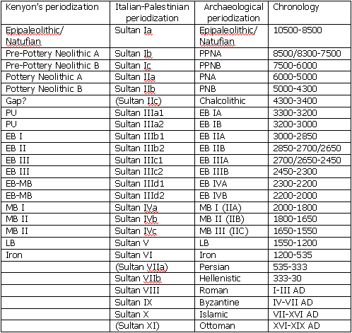
The following summary presents the excavations results in stratigraphic and chronological order, following the most recent periodization, where the Early Bronze Age is represented by the four phases of Sultan IIIa-d, covering a period which lasted from the last third of the IV millennium BC till the end of the III millennium BC, and the Middle Bronze Age is represented by the three phases of Sultan IVa-c, from the beginning to the middle of the II millennium BC.
2. Sultan IIIb - Early Bronze II (3000-2700/2650 BC)
The earliest data collected by the Italian-Palestinian Expedition so far concern period Sultan IIIb, corresponding to the Early Bronze II. At the beginning of the period, the erection of the first Early Bronze Age fortifications marks the definitive establishment of a city, which spread off as a physiological development from the previous proto-urban village of Sultan IIIa2 (Early Bronze IB). This earliest urban phase has been detected on the northern side of the site, where excavations in Area L allowed to identify the remains of a massive mud-brick city-wall, already excavated by Sellin and Watzinger, and plotted in purple colour on their plan, which is apparently the earliest urban fortification system, dating from period Sultan IIIb, Early Bronze II. The identification of the EB II city-wall represents one of the most prominent results of the latest seasons in the larger perspective of studying the earliest urban development in the Southern Levant, in which the ancient walled town of Jericho represents an utmost example of an articulated architectural work realized by a complex society. The EB II city-wall is made of very distinguished dune-yellowish mud-bricks, already noticed by previous excavators, and characterized by their large size. The contemporary layers in the nearby dwelling quarter were reached in Area F, where the main feature was a street running south-west/north-east (L.435), that was in use during the entire EB urban period (Sultan IIIb-IIIc) with roughly the same outline. On both sides of the street, several units were brought to light, as completion of the houses already excavated by the Austro-German and the British Expeditions. In one of the rooms, Light Faced Painted Ware (Abydos Ware) jar fragments were found .
On the basis of these new data, and the renewed interpretation of previous expeditions results, the general urban layout of Tell es-Sultan in the Early Bronze II can be described as follows: the city was protected by massive walls, made of dune yellowish mud-bricks; its main gate was on the south-eastern side, in front of the Spring, and a main street crossed it south-north, climbing the Spring Hill from south-east and descending it towards north-east.
3. Sultan IIIc1 - Early Bronze IIIA (2700/2650-2450 BC)
In the following period of Sultan IIIc1 (Early Bronze IIIA), the city was rebuilt with several important transformations affecting the fortification system, and consequently the general urban layout, and the outline of the dwelling quarters.
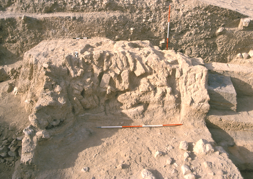
A completely new composite double city-wall was built - with separated juxtaposed blocks - all around the site, overlapping the previous solid wall only on the western and part of the northern side. It was made of an inner main wall up to 4.0 m thick, protected on the outer side by a filling sustained by an outer wall (1.5-1.6 m thick). The gap between the inner and outer walls was either filled up with crushed limestone (hawwara), or with soil resulting from razing activities on the previous city collapsed strata, or hosted blind rooms (a kind of "casemates") related to the main wall and used as storerooms or pathways. This articulated system, which at several spots also foresaw a ditch at the bottom of the outer wall, and reached an overall thickness of 12 m, was a major achievement of the Jericho ruling institution in the Early Bronze IIIA, and was at last investigated by the Italian-Palestinian Expedition in Area B West, at the south-west corner of the site, where the nature of the filling in between the inner and outer walls was clarified, and the stratigraphy of the two superimposed main fortification systems (previously interpreted by K.M. Kenyon as a sequence of at least 17 different phases), belonging respectively to Sultan IIIc1 and IIIc2, was definitively established.
As regards the general urban layout, the investigation in Area D, though not reaching Early Bronze III layers, supported the hypothesis that the main city-gate during this period was located at the south-eastern foot of the Spring Hill in front of the 'Ain es-Sultan. On the other hand, excavations in Area G, on the preserved top of the Spring Hill, have shown that a main retaining wall supported the central area of the site, where public buildings were located (see below).
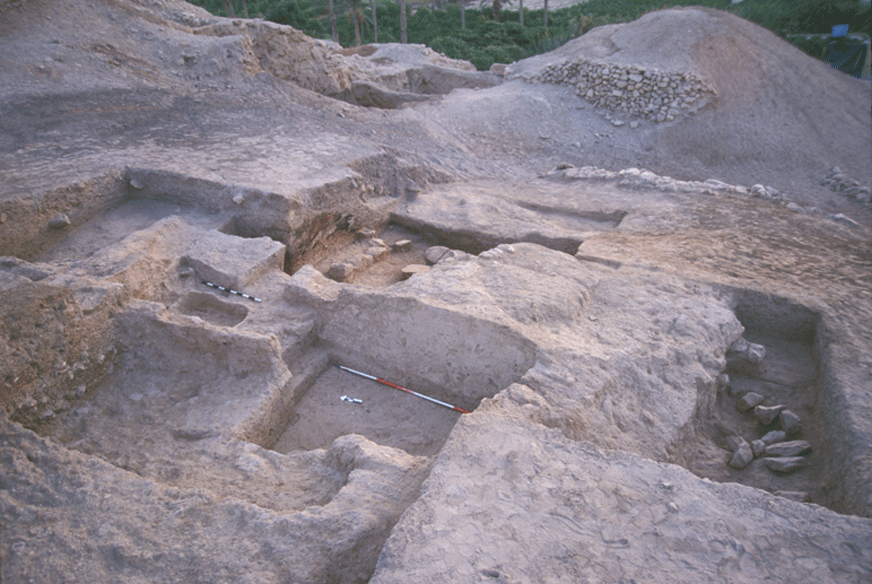
The main street crossing the city south-west/north-east was one of the Sultan IIIb features kept in this period, as the excavations in Area F, on the northern plateau of the tell, demonstrated. Here, a huge portion of the dwelling quarter extending to the west and to the east of the street running north-east, at this stage named L.307, was brought to light. Eight domestic units (from south to north, L.450, L.323, L.319, L.305+L.327, L.303, L.403+L.405, L.445, L.904) in a fairly good state of preservation were exposed on the eastern side of the street, and one more unit (L.444) was uncovered on its western side. Only L.904 opened directly towards the street, through a doorway (L.902) with a raised threshold paved with three stone slabs. Further to the north, the street was brought to light up to the edge of denudation of previous excavations, thus showing that the it turned slightly towards north-east. Architecture shows the use of mud-bricks on field-stones foundations only at the moment of the first erection of buildings. In the following reconstructions, walls were raised horizontally, and new mud-brick structures were built directly upon them without stone foundations. This made obviously quite complicated to investigate the constructional history of each house, also because the same houses were repaired many times and continuously used with varying layouts. Each domestic unit was provided with a hearth and various working installations, such as benches, cutting and grinding slabs, pulping holes. Another common architectural feature is the use of timber as pillars, often inserted within walls, or freestanding on stone bases, as known in many other Palestinian sites.
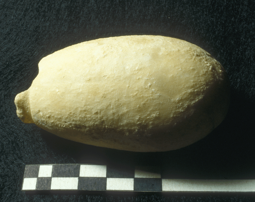
Findings belong to the ordinary domestic assemblage, mainly illustrating food production and preparation: flint blades and sickles, stone pestles and grinding stones. Faunal remains, among which several bones belonging to butchered animals, show an integrated diet of tamed animals (sheep and goats, but also bovines), and wild species, such as gazelle and wild boar. A hippopotamus bone, found in the 1998 campaign, deserves a particular interest; cutting marks indicate that it was butchered in the house. The presence of such an animal in the Jericho Oasis not only is the latest attestation in inland Palestine, but also testifies to the abundance of water sources in the Lower Jordan Valley, especially by the 'Ain es-Sultan and the nearby 'Ain el-Lodjia. The bull's head found by John Garstang and made of hippopotamus tusk ivory may be, thus, locally manufactured, as well as another similar specimen from an unknown spot of the site.
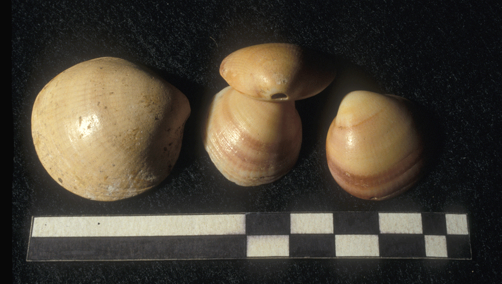
Other domestic activities are testified to by items such as worked bones, bone and copper pins, and loom weights and spindle whorls related to household textile production. Clay disks may be interpreted as counterweights used in weaving activities, as they were found together with spindle whorls and loom weights; sea-shells and mother-of-pearl fragments hint at commercial links with the Red Sea and the Mediterranean Sea. Especially, sea-shells have a large attestation, being often pierced at their hinge, presumably in order to be hung in laces. Due to their high number in EB III contexts, anyway, it has been also suggested that they were used as counters or represented some sort of tallying system in a kind of pre-administrative procedures. Actually, the existence of a productive system coordinated by a central administration is perhaps more consistently demonstrated by findings such as balance weights (of 2 shekels and 1 mine), which are possibly related to metal and other precious stuff (sulphur, salt, ointments, drugs, bitumen, etc.) exchange.
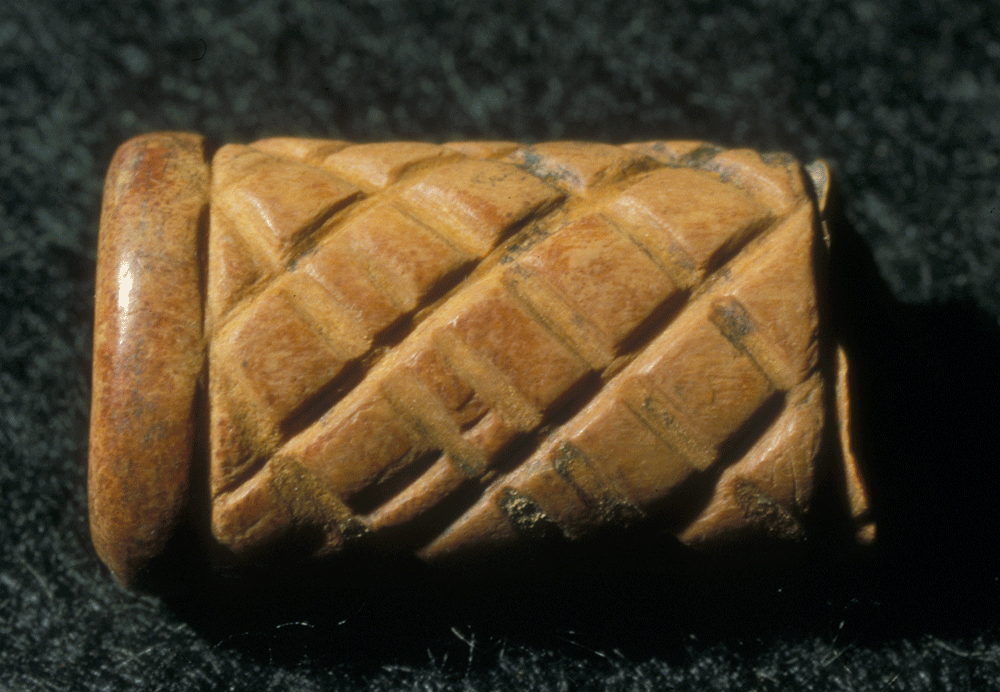
More rare finds are metals, such as an arsenical copper pivot and an enrolled foil, possibly belonged to wooden furniture, as well as a worked bone cylinder, decorated with a hatched motive, which is fairly typical of the period. The pottery assemblage of this phase included Simple Ware vessels decorated with a reddish painting or wash, Red-Polished Ware (a globular juglet with a couple of knobs is a distinguished type), and various shapes of Khirbet Kerak Ware. The latter specialised production seems to have a relatively wide attestation in the inventory of Sultan IIIc1. It is noteworthy that together with specimens clearly imported from the North, mainly retrieved in contemporary tombs, KKW fragments from the site suggest the existence of a local manufacture of such ware, which is distinguished by the firing (at a slightly less high temperature, which results in a dark grey or orange colour of surface, instead of black and red), and by a prevalence of small open shapes such as slightly carinated bowls.
4.Sultan IIIc2 - Early Bronze IIIB (2450-2300 BC)
The general layout of the city was preserved in Sultan IIIc2, when, following a violent destruction, Jericho was fully rebuilt. The double city-walls were investigated in Area B and B West, at the south-western corner of the city. The Inner Wall (W.1), both in Area B and B West, resulted to have been repaired in various spots, while the Outer Wall (W.51) had been moved inwards and rebuilt with a thickness of 3.0 m. On the southern side of the fortifications, excavations in Area B exposed Building B1, a structure erected against the Inner City-Wall.
The building included a row of rectangular rooms (L.38, L.39, L.539), parallel to the city-wall, and a main east-west wall (W.34+W.534), delimitating a courtyard. Even if, due to erosion and previous excavations, these rooms were only partially preserved, finds suggest that they was devoted to food production: three limestone mortars where found in L.39, while L.38 was characterized by the presence of a hearth in a corner, paved with basalt stones and reemployed grinders.
The plan, the number of rooms, the thickness of walls and their building technique, suggest that Building B1 had a public function, hosting extra-familiar food production. Building B1 was destroyed by a violent earthquake, as it is shown by its main wall ruinously collapsed, and it is also visible in cracks and subsided sections of the nearby city-walls . Calibrated radiocarbon dates allow to fix this event around 2350 BC. Successively, the area was re-occupied by the same inhabitants for some decades. Then, the site was definitively abandoned.
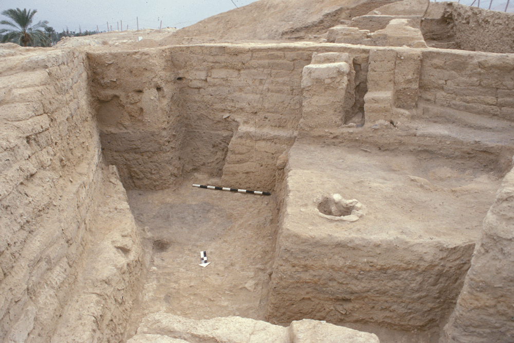
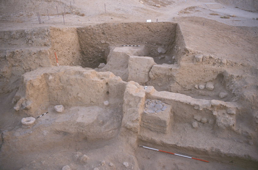
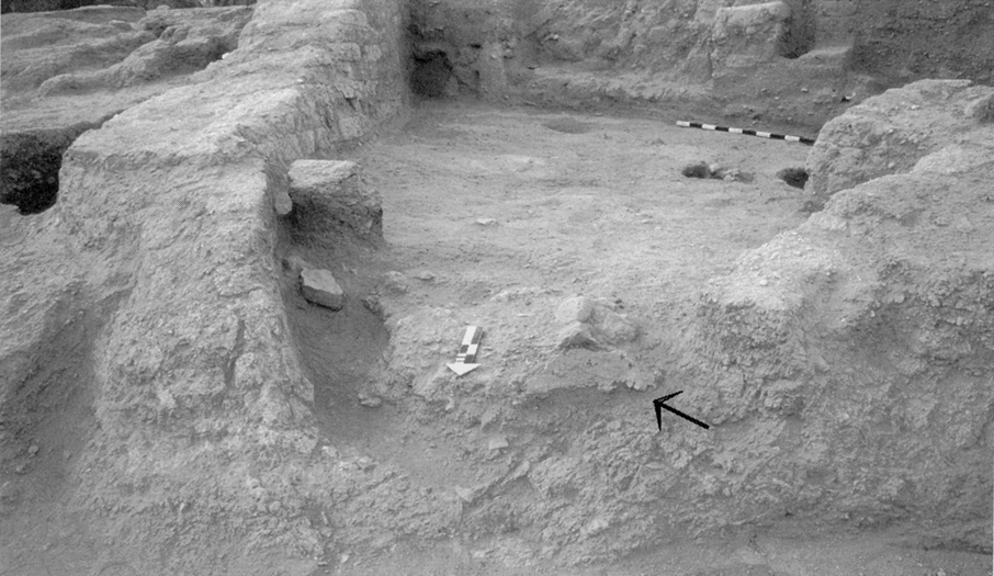
Further insights within public architecture and history of Tell es-Sultan during Period IIIc2 (EB IIIB) were provided by excavations in Area G, on the preserved top of the Spring Hill. Here, a major building (Building G1) was discovered, after the removal of extensive pits (F.601 and F.603) from the Byzantine period, with 1.0 m thick plastered walls, showing a size and a plan markedly different from that of contemporary domestic architecture. Three rooms of Building G1 were fully exposed (L.620, L.644 and L.961), with thick mud-brick walls, showing a line lime revetment, and a series of modelled installations. In the smallest room (L.620) a plastered bin was present along the north wall (B.618), probably for working with liquid substances. The main room to the east (L.644) was destroyed by a fierce fire and the roof collapsed all together, as testified to by the carbonized wooden beams, fallen over the floo r and found still parallel one to the other.
Six large storage jars were found in this room proving that it was also devoted to storage, being at the same time employed for transformation of food, as attested to by flint blades, flat stones used as working surfaces, benches (B.640 and B.645), and series of clay bins.
A third room to the east (L.961), aligned with the previous ones, was identified only in its southern wall (W.616), which confirms a certain degree of monumentality for the building: its scale, its location and the wealth of archaeological finds suggest that it had a public function.
After its destruction, due to the earthquake already noticed in Area B, which occurred towards the end of Period IIIc2 (around 2350 BC), Building G1 was rebuilt in a less monumental way, and then definitely abandoned around 2300 BC.
5. Sultan IIId - Early Bronze IV (2300-2000 BC)
Early Bronze IV marks a distinct change in the life of Tell es-Sultan, which was first deserted for a certain while, and then reoccupied by a new rural community. This pattern of development of the site, which has been reconstructed re-evaluating finds of the Austro-German and British Expeditions, in the light of the Italian-Palestinian updated stratigraphy, has been fruitful compared with that of the huge necropolis excavated by K.M. Kenyon, establishing an early phase (Sultan IIId1), when, after a certain gap in occupation, sparse dwellings occupied the summit of the Spring Hill, and a second phase (Sultan IIId2), when the settlement became a huge rural village, and also the slopes of the tell were inhabited after having been appropriately terraced. The Italian-Palestinian Expedition identified remains of Period IIId on top of the Spring Hill, and in the northern plateau of the tell; namely, dwellings, including ovens, silos, floors, and flimsy mud-brick walls, often made of reemployed bricks from Period IIIc2 collapsed structures.
6. Sultan IVa - Middle Bronze I (2000-1800 BC)
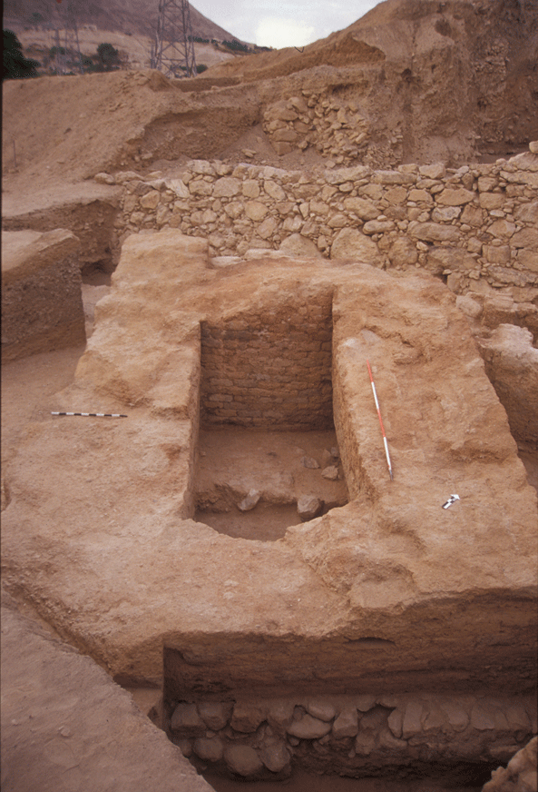
Still partially unknown socio-political changes, occurring at the eve of the 2nd millennium BC, are perhaps reflected in the rebirth of a fortified city at Tell es-Sultan, which designates the beginning of the Middle Bronze Age (Sultan IVa). The formative phase of the new city is a very complex and still under investigation topic, and the Italian-Palestinian Expedition tried to select spots suitable for its reconstruction. One is the Spring Hill, on the top of which, in Area G, a major sustaining wall (W.633) was identified, presumably terracing the acropolis with public buildings, and at the bottom of which, in Area D, cleaning works brought to light a huge mud-brick wall (W.7), just in front of the Spring, cut by the modern road.
This wall, at its southern end, may be identified with the structure already excavated by J. Garstang protruding from the East Tower (a massive defensive building possibly connected to a gate), while, at its northern end, was excavated by K.M. Kenyon (HCJ+HCP), who also identified a rectangular tower (HBL+HBJ+HBK) connected with it. A sounding below the foundations of Wall W.7 proved that it and the related tower can be attributed to Sultan IVa. Excavations in Area A, on the southern flank of the tell, brought about the discovery of Building A1, a huge building with a rectangular tower, which was erected during Sultan IVa, and kept in use during Sultan IVb (see below). The building technique of Tower A1, its orientation and its function are very similar to those of Garstang's East Tower, suggesting that both monuments belonged to the same early Middle Bronze Age fortification system of Tell es-Sultan, consisting of a solid mud-brick wall 2 m thick, as like as in many other Palestinian sites, with various buttresses and towers.
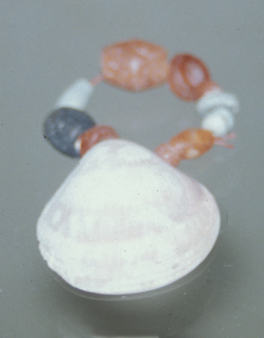
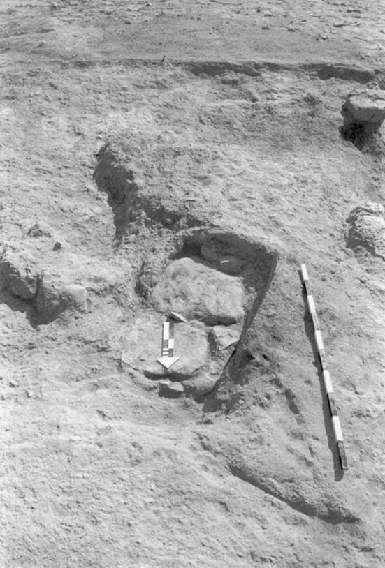
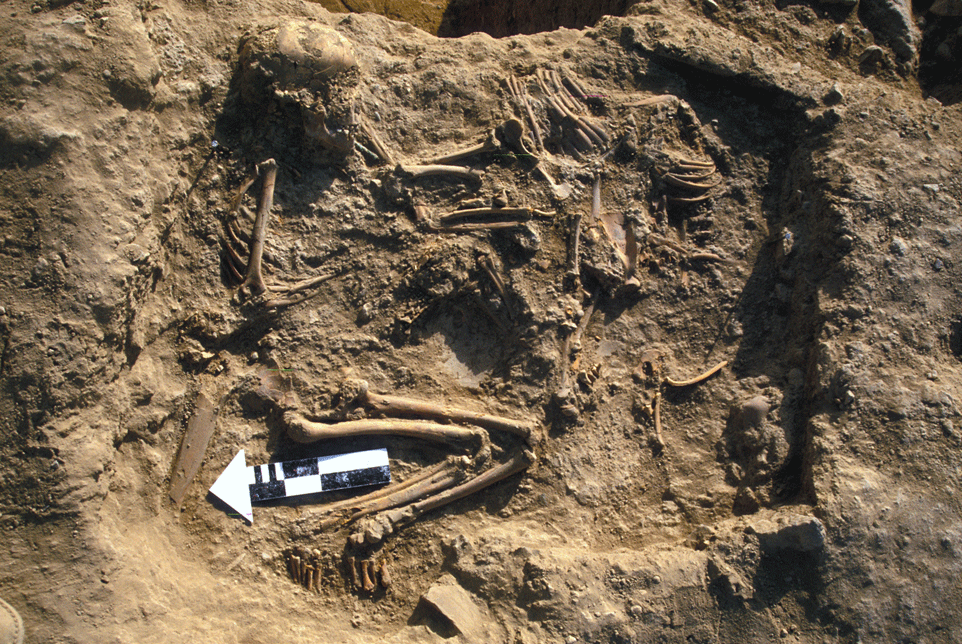
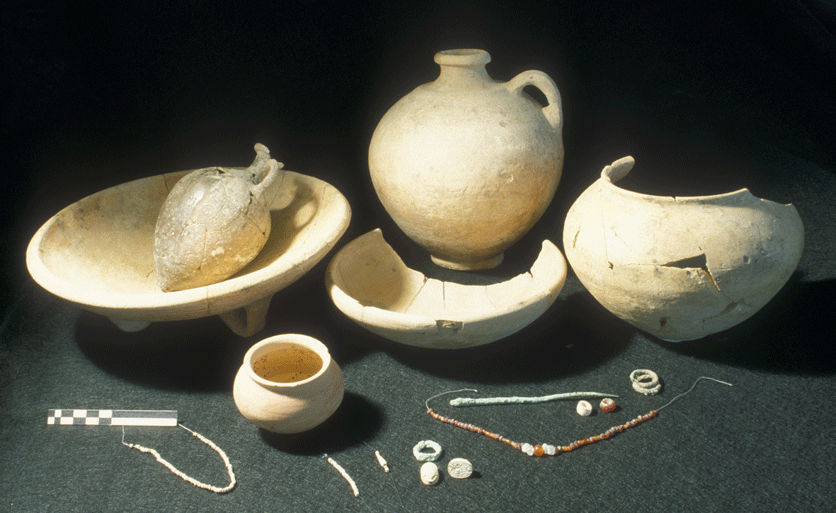
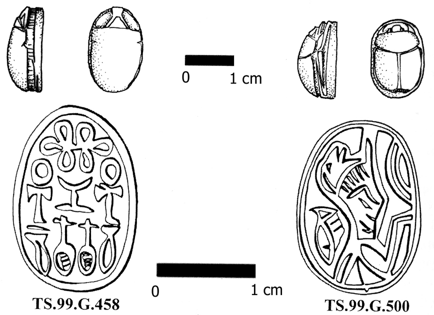
On the top of the hill, in Area G, terrace-wall W.633, made of big fieldstones, sustained a public building (the north-western counterpart of this terrace wall was identified with W.420 in Area F), largely disappeared due to intense disturbing activities in the Byzantine period. Underneath this building, the southern wing of which was identified by Sellin, there was a group of built-up tombs with relatively wealthy funerary assemblages, which, for their location and general characteristics may be interpreted as princely burials beneath the palace. One of these tombs (D.641) was discovered by the Italian-Palestinian Expedition. In the tomb two flexed bodies were buried, apparently an adult and a female about 12-14 years old, with two sacrificed kid animals (a gazelle and a goat) and six vessels of which at least one contained food offerings.
The young lady wore a pair of bronze double earrings, a necklace of carnelian and rock crystal beads, a bronze pin for closing the tunic on the left shoulder, some chains of frit beads and a digital bronze ring with a steatite scarab of local manufacture, while another scarab was found under the left side of the head.
In Area F, terrace-wall W.420 , made of big fieldstones and oriented as W.633, was identified supporting the uppermost area of the site, where a major building was erected, a wall of which was excavated in 1999 (W.431).
In respect of the Early Bronze Age city, that of the beginning of Middle Bronze Age was characterized by the enucleation of a major dominant urban area on top of the Spring Hill, extending towards north with a rectangular plan around 100 x 50 m, where the palace (and perhaps also the main city-temple) was located, and by a completely new fortification system built at the bottom of the tell, and consisting of a solid mud-brick wall with towers at regular intervals (see below).
7. Sultan IVb - Middle Bronze II (1800-1650 BC)
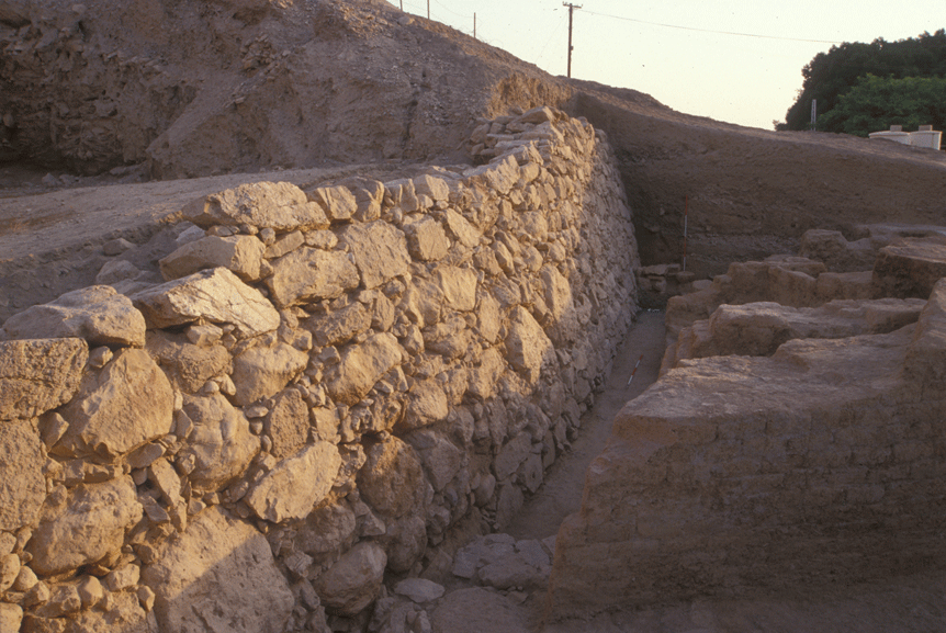
After a major destruction, occurred towards the end of Sultan IVa (Sesostris III's campaign?), the city of Jericho was again rebuilt and a new fortification system was erected all around the tell, consisting of a rampart made up by a massive stone wall at its outer bottom (partly reusing, partly reconstructing the previous mud-brick city-wall), supporting a series of earthen fillings with a crushed limestone or clay revetment, and of an upper wall with subsidiary buildings over it.
A long stretch of the stone wall at the base of the rampart has been brought to light in Area E, at the south-western corner of the site. At the middle of this wall a rectangular structure protrudes out of the line of the city fortification, possibly the foundation of a defensive tower. Inside the Tower, in a layer of destruction apparently belonging to MB II, a clay figurine of a lioness was found.
The upper part of the rampart was examined during the first two seasons in Area C, at Kenyon's Trench I, where a series of supporting walls were identified just below its top. At different sites around the tell the rampart was made with different techniques, so that it is yet complicated to identify the exact phase of utilization of each stretch.
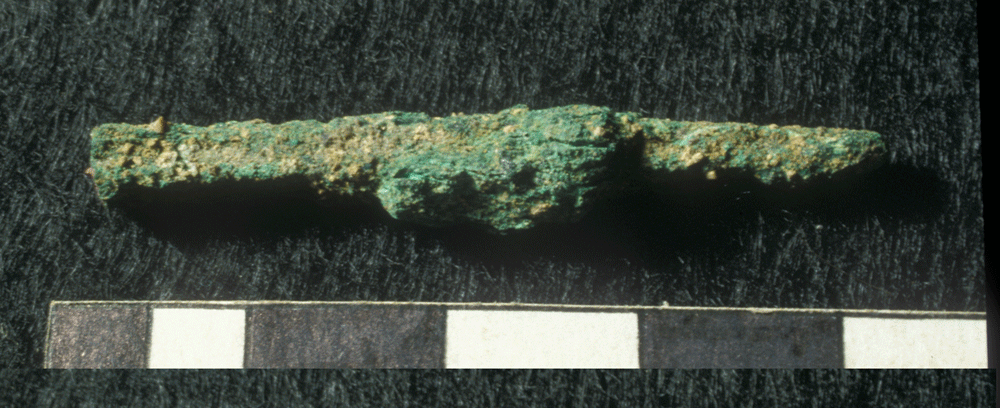
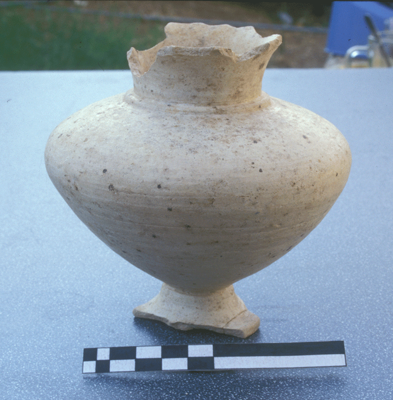
A major result of the Italian-Palestinian Expedition was the discovery of a Middle Bronze II lower city, encompassing the tell on the eastern and southern sides, and including the spring within the fortified urban area. In Area A, just south of Kenyon's Trench III, the defensive building (A1) continued to be in use, and its abutting tower (fig. 49) was now encircled by houses, as the city was enlarged towards the Oasis. While on the eastern side private houses abutted over the Tower, on the western side, a wide area interpreted as an inner courtyard of a fortress, was paved with pebbles and clear from buildings; moreover, the western wall of the Tower (W.19), stretched north-west and south-east, thus indicating that the Fortress was a huge one. The group of houses built outside Building A1 and against the Tower, had three main reconstructions during Sultan IVb. These houses gave a large inventory of domestic items and pottery, as well as some interesting finds, such as a calcite alabastron, and a bronze adze. Sultan IVb was perhaps the most flourishing phase in the history of the Middle Bronze Age city of Jericho, as it is also shown by the rich necropolis, and it ended in the second half of the 17th century, due to an unknown cause.
A violent destruction brought to a sudden end the city of Period IVc, around 1550 BC or some years later. There is no available evidence for attributing this event to some enemy, even though one has to stress the strategic importance of the site, the southern gate of the Jordan Valley. The intervention of a strong foreign power seems, thus, historically possible, since the city was so badly shattered that it was abandoned for various centuries and the inhabitants probably moved to another area in the Jericho Oasis.
8. Sultan IVc - Middle Bronze III (1650-1550 BC)
A major transformation of the city marked an overall urban reorganization at Tell es-Sultan and the last stratigraphic phase of development of the Middle Bronze Age, Sultan IVc. The latter phase was investigated by the Italian-Palestinian Expedition mainly in Area A, where the building technique of the third and last rampart was definitely clarified. At the beginning of Sultan IVc (Middle Bronze III), the city of Jericho was again reduced in size, and part of the southern Lower Town was razed for the construction of a rampart sustained by a massive stone retaining wall set within a foundation trench and covered by a sloping embankment with a superficial revetment of crushed limestone. The Cyclopean wall, already excavated especially by the Austro-German Expedition, was not to be seen in the intentions of its builders. This datum is even mostly significant since similar defensive structure were excavated in many other Palestinian sites, such as Khirbet Seilun, Tell Balatah and Tell el-Mutesellim (northern Lower Town).
A violent destruction brought to a sudden end the city of Period IVc, around 1550 BC or some years later. There is no available evidence for attributing this event to some enemy, even though one has to stress the strategic importance of the site, the southern gate of the Jordan Valley. The intervention of a strong foreign power seems, thus, historically possible, since the city was so badly shattered that it was abandoned for various centuries and the inhabitants probably moved to another area in the Jericho Oasis.
9. Sultan V-VI - Late Bronze and Iron Ages (1550-535 BC)
A few materials and some tombs are known from period V, the Late Bronze Age, even though not a single pottery fragment from this period was found on the tell by the Italian-Palestinian Expedition. Iron Age materials were found in Area B, while in Areas G and F on the summit of the Spring Hill and on the northern plateau intensive razing of later periods had removed all strata down to the Middle or even to the Early Bronze Age.
10. Area H: Byzantine Occupation of the Summit of the Tell
In Area H, on the summit of the tell, to the north of the tourist shelter, on a saddle between Areas G and F, burnt remains of a collapsed building were clearly visible on the surface suffering erosion.
The sounding was limited to a single square (BeII19), where a Byzantine mid-6th century AD house (L.707) was discovered. An interesting set of materials (pottery, glasses and objects), including many fragmentary "Gaza Ware" amphoras, was retrieved. In year 2000, the exploration was extended surveying several stone structures visible on the surface, clearly contemporary with the house previously discovered. Six houses were identified, bordered by open spaces and refuse pits. A bronze lock of a wooden box was found on the surface. The Byzantine settlement thus seems to have been a small rural village resting upon the ruins of the preceding cities, in an area roughly corresponding to the northern and eastern parts of the tell.
11. Conclusions
The joint Italian-Palestinian Expedition at Tell es-Sultan has provided new insights into the urban structure of the Bronze Age city, focusing not only on the fortification systems, but also on the detailed urban history throughout the III and II millennia BC, and on the changes in material culture, in order to get a closer historical understanding of the archaeology of Jericho and the southern Jordan Valley. In the years which followed the forced stop of activities on the field (2001-2005), the Expedition continued to study materials, publishing a series of studies and articles. Moreover, the team of Rome "La Sapienza" University started a series of study programs with a group of PhD students, focused on the archaeology of Jericho and Palestine. The same team is, of course, eager of resuming restoration and excavation activities at Tell es-Sultan, however, with the awareness that such activities are conceivable only within the overall project of the Archaeological Park of the Jericho Oasis under the supervision of the Department of Antiquities and Cultural Heritage of the Palestinian National Authority.
Bibliography
Alhaique, F.
2000 "Appendix B. Faunal Remains of the 1998 Excavation Campaign at Jericho", in Marchetti - Nigro (eds.) 2000, pp. 297-317.
in press "Un ippopotamo a colazione? Presenza olocenica di Hippopotamus amphibius in un sito interno del Levante del Sud (Bronzo Antico)", in Atti del 3° Convegno Nazionale di Archeozoologia (Siracusa 3-5 Novembre 2000), in press.
Ascalone, E.
in press "Distribution and Archaeological Context of the Balance Weights from Tell es-Sultan/Jericho", in M. Alberti - E. Ascalone - L. PEYRONEL (eds.), Weights in Contexts. Bronze Age Weighing Systems of Eastern Mediterranean. Chronology, Typology, Material and Archaeological Contexts (Rome 22-24/11/04), Rome in press.
Fischer, P.M.
2002 "Egyptian-Transjordanian Interaction during Predynastic and Protodynastic Times: The Evidence from Tell Abu al-Kharaz, Jordan Valley, in E.C.M van den Brink - Th.E Levy (eds.), Egypt and the Levant. Interrelations from the 4th through the Early 3rd Millennium B.C.E., London - New York 2002, pp. 323-333.
Garstang, J.
1930 "Jericho, Sir. Charles Marston's Expedition of 1930", in Palestine Exploration Fund. Quarterly Statement 62 (1930), pp. 123-132.
1931 "The Walls of Jericho. The Marston-Melchett Expedition of 1931", in Palestine Exploration Fund. Quarterly Statement 63 (1931), pp. 186-196.
1932 "Jericho: City and Necropolis", in Liverpool Annals of Archaeology and Anthropology 19 (1932), pp. 3-22, 35-54.
Garstang, J. et al.
1935 "Jericho: City and Necropolis (Fifth Report)", in Liverpool Annals of Archaeology and Anthropology 22 (1935), pp. 143-184.
Garstang, J. - Garstang, J.B.E.
1948 The Story of Jericho, London 1948.
Holland, Th.A.
1987 "Jericho and the Proto-urban period", in S. Shaath (ed.), Studies in the History and Archaeology of Palestine (Proceedings of the First International Symposium on Palestine Antiquities), II, Aleppo 1987, pp. 17-25.
Lloyd, S.
1978 The Archaeology of Mesopotamia. From the Old Stone Age to the Persian Conquest, London 1978.
Kenyon, K.M.
1957 Digging Up Jericho, London 1957.
1960 Excavations at Jericho. Volume One. The Tombs excavated in 1952-1954, London 1960.
1981 Excavations at Jericho. Volume Three. The Architecture and Stratigraphy of the Tell, London 1981.
Kenyon, K.M. - Holland, Th.A.
1983 Excavations at Jericho. Volume Five. The Pottery Phases of the Tell and Others Finds, London 1983.
Marchetti, N.
1999 "A Middle Bronze II Alabastron from Tell es-Sultan/Jericho and a Syro-Palestinian Class of Alabaster Vessels", in ISIMU 2 (1999), pp. 305-312.
2003a "A Century of Excavations on the Spring Hill at Tell es-Sultan, Ancient Jericho: A Reconstruction of Its Stratigraphy", in M. bietak (ed.), The Synchronisation of Civilisations in the Eastern Mediterranean in the Second Millennium B.C. II (Proceedings of the SCIEM 2000 - EuroConference, Haindorf 2nd of May - 7th of May 2001), Wien 2003, pp. 295-321.
2003b "Due scarabei in steatite del Bronzo Medio I finale da Tell es-Sultan, antica Gerico", in Ricerche di Egittologia e di Antichità copte 5 (2003), pp. 9-22.
Marchetti, N. - Nigro, L.
1995-1996 "Handicraft Production, Secondary Food Transformation and Storage in the Public Building P4 at EB IVA Ebla", in Berytus 42 (1995-96), pp. 9-36.
1998 "Tell es-Sultan, antica Gerico", in L. Drago Troccoli (a cura di), Scavi e ricerche archeologiche dell'Università di Roma "La Sapienza" (Studia Archaeologica 96), Roma 1998, pp. 277-283.
1999 "Two Seasons of Excavations of the Italian-Palestinian Expedition at Tell es-Sultan/Jericho", in AA.VV., Culture in Sustainable Development. An Italian Strategy. Research and Pilot Projects on Archaeology and Anthropology, Rome 1999, pp. 103-107.
Marchetti, N. - Nigro, L. (eds.)
1998 Scavi a Gerico, 1997. Relazione preliminare sulla prima campagna di scavi e prospezioni archeologiche a Tell es-Sultan, Palestina (Quaderni di Gerico 1), Roma 1998.
2000 Excavations at Jericho, 1998. Preliminary Report on the Second Season of Excavations and Surveys at Tell es-Sultan, Palestine (Quaderni di Gerico 2), Rome 2000.
in press Excavations at Jericho, 1999-2000. Preliminary Report on the Third and Fourth Seasons of Excavations and Surveys at Tell es-Sultan, Palestine (Quaderni di Gerico 3), Rome in press.
Marchetti, N. - Nigro, L. - Sarie', I.
1997 "First Season of Excavations of the Italian-Palestinian Expedition at Tell es-Sultan/Jericho, April-May 1997", in Orient Express 1997/2, pp. 1-4.
1998 "Preliminary Report on the First Season of Excavations of the Italian-Palestinian Expedition at Tell es-Sultan/Jericho, April-May 1997", in Palestine Exploration Quarterly 130 (1998), pp. 121-144.
Marchetti, N. - Nigro, L. - Taha, H.
2000 "Preliminary Report on the Second Season of Excavations of the Italian-Palestinian Expedition at Tell es-Sultan/Jericho, 1998", in P. Matthiae - A. Enea - L. Peyronel - F. Pinnock (eds.), Proceedings of the First International Congress on the Archaeology of the Ancient Near East, Rome, May 18th-23rd 1998, Rome 2000, pp. 869-901.
in press "Urban Plan, Stratigraphy and Chronology of Bronze Age Jericho in the Light of the Italian-Palestinian Expedition", in J. Margueron - P. de Miroschedji - J.P. Thalmann (eds.), Proceedings of the Third International Congress on the Archaeology of the Ancient Near East, Paris in press.
Marchetti, N. - Nigro, L. - Yasin, J.
1999 "Second Season of Excavations of the Italian-Palestinian Expedition at Tell es-Sultan/Jericho, October-November 1998", in Orient Express 1999/1, pp. 17-20.
Marchetti, N. - Nigro, L. - Yasin, J. - Ghayada, M.
2000 "Third Season of Excavations of the Italian-Palestinian Expedition at Tell es-Sultan/Jericho, October-November 1999", in Orient Express 2000/4, pp. 82-84.
Matthiae, P.
1997a "Ricerche archeologiche a Tell es-Sultan/Gerico", in Missioni Archeologiche Italiane. La ricerca archeologica, antropologica, etnologica, Roma 1997, pp. 253-256.
1997b La storia dell'arte dell'Oriente Antico. I primi imperi e i principati del ferro. 1600-700 a. C., Milano 1997.
2000 La storia dell'arte dell'Oriente Antico. Gli stati territoriali. 21000-1600 a. C., Milano 2000.
Matthiae, P. - Marchetti, N. - Nigro, L. - Taha, H.
1999 "Two Seasons of Excavations of the Italian-Palestinian Expedition at Tell es-Sultan/Jericho 1997-1998", in Culture in Sustainable Development. An Italian Strategy. Research, Rome 1999, pp. 103-107.
Nigro, L.
1996-1997 "Gerico: le origini della città in Palestina. Caratteri generali, sviluppo e crisi della prima urbanizzazione palestinese nel III millennio a.C.: il caso di Tell es-Sultan, antica Gerico", in Rendiconti della Pontificia Accademia Romana di Archeologia 69 (1996-97), pp. 187-218.
2003 "Tell es-Sultan in the Early Bronze Age IV (2300-2000 BC.). Settlement Vs Necropolis - A Stratigraphic Periodization", in Contributi e Materiali di Archeologia Orientale IX (2003), pp. 121-158.
2005 Tell es-Sultan/Gerico alle soglie della prima urbanizzazione: il villaggio e la necropoli del Bronzo Antico I (3300-3000 a.C.) (Rome "La Sapienza" Studies on the Archaeology of Palestine & Transjordan, 1), Roma 2005.
in press a "Sulle mura di Gerico. Le fortificazioni di Tell es-Sultan come indicatori della nascita e dello sviluppo della prima città di Gerico nel III millennio a.C.", in Festschrift Matthiae (in press).
in press b "Le tombe principesche sulla "Spring Hill" e le altre sepolture intramurali a Gerico nel II millennio a.C.", in G. Bartoloni et al. (eds.), Sepolti tra i vivi. Atti del Convegno di Roma, Roma in press.
Peyronel, L.
2004 Gli strumenti di tessitura dall'età del Bronzo all'epoca persiana (Materiali e Studi Archeologici di Ebla IV), Roma 2004.
Sellin, E. - Watzinger, C.
1913 Jericho. Die Ergebnisse der Ausgrabungen (Wissenschaftliche Veröffentlichung der Deutschen Orient-Gesellschaft 22), Leipzig 1913.
Tubb, J.N.
1998 Canaanites, London 1998.
Tubb, J.N. - Dorrell, P.G.
1994 "Tell es-Sa'idiyeh 1993: Interim Report on the Seventh Season of Excavations", in Palestine Exploration Quarterly 126 (1994), pp. 52-67.
The archaeologists and technicians of Rome "La Sapienza" University spent four unforgettable seasons at Tell es-Sultan together with the Palestinian friends of the Department of Antiquities and Cultural Heritage, and the scientific results of such excavations - which were announced at the International Congresses of Near Eastern Archaeology held in Rome, Copenhagen and Paris - changed several interpretations concerning the Bronze Age city, which flourished on the limestone bank nearby 'Ain es-Sultan for more than one millennium. The Expedition updated the chronology of the constructive phases of the Early Bronze Age city-walls and of the Middle Bronze Age ramparts, consistently demonstrated the existence of a Lower City, unfortunately destroyed by modern building activities, and discovered huge buildings on top of the site and at its southern foot.
A brief summary of the discoveries is offered hereby, which is aimed at giving an idea of the monumental evidence available from a site which deserves, through the UNESCO nomination, not only the worldwide fame (which, actually, it already has), but also the world help to become the core of the first Palestinian National Archaeological Park.
1. Introduction
2. Sultan IIIb - Early Bronze II (3000-2700/2650 BC)
3. Sultan IIIc1 - Early Bronze IIIA (2700/2650-2450 BC)
4. Sultan IIIc2 - Early Bronze IIIB (2450-2300 BC)
5. Sultan IIId - Early Bronze IV (2300-2000 BC)
6. Sultan IVa - Middle Bronze I (2000-1800 BC)
7. Sultan IVb - Middle Bronze II (1800-1650 BC)
8. Sultan IVc - Middle Bronze III (1650-1550 BC)
9. Sultan V-VI - Late Bronze and Iron Ages (1550-535 BC)
10. Area H: Byzantine Occupation of the Summit of the Tell
11. Conclusions
Bibliography
1. Introduction
In 1997, the main goals of the Italian-Palestinian Expedition at Tell es-Sultan/ancient Jericho were, of course, resuming archaeological excavations at such an important site, at the crossroads of many cultural areas and different environments, which has provided one of the most complete chronological sequence in pre-classical Palestine, but also starting a pilot project of cooperation between the Palestinian Department of Antiquities and Cultural Heritage, and Rome "La Sapienza" University, which foresaw the training of young Italian and Palestinian archaeologists. The main focus of the Expedition during the four campaigns (1997-2000) was the investigation of the urban plan, stratigraphy and culture of the Bronze Age city (Sultan III-IV), also re-evaluating data collected by previous Austro-German and British Expeditions.
This task was accomplished opening nine excavation areas, with interesting results concerning the site topography and extension, the development of its fortification system, and the stratigraphic sequence, which has also allowed a reappraisal of finds of previous expeditions.
The fourth and last season of excavations of the Italian-Palestinian Expedition at Tell es-Sultan/Jericho took place in September-October 2000; unluckily, it was interrupted due to the severe political situation. Nevertheless, since then, the study of the results, stratigraphy and finds, produced by the Italian-Palestinian Expedition has continued, updating the archaeological knowledge of the history of the site.
The following summary presents the excavations results in stratigraphic and chronological order, following the most recent periodization, where the Early Bronze Age is represented by the four phases of Sultan IIIa-d, covering a period which lasted from the last third of the IV millennium BC till the end of the III millennium BC, and the Middle Bronze Age is represented by the three phases of Sultan IVa-c, from the beginning to the middle of the II millennium BC.
2. Sultan IIIb - Early Bronze II (3000-2700/2650 BC)
The earliest data collected by the Italian-Palestinian Expedition so far concern period Sultan IIIb, corresponding to the Early Bronze II. At the beginning of the period, the erection of the first Early Bronze Age fortifications marks the definitive establishment of a city, which spread off as a physiological development from the previous proto-urban village of Sultan IIIa2 (Early Bronze IB). This earliest urban phase has been detected on the northern side of the site, where excavations in Area L allowed to identify the remains of a massive mud-brick city-wall, already excavated by Sellin and Watzinger, and plotted in purple colour on their plan, which is apparently the earliest urban fortification system, dating from period Sultan IIIb, Early Bronze II. The identification of the EB II city-wall represents one of the most prominent results of the latest seasons in the larger perspective of studying the earliest urban development in the Southern Levant, in which the ancient walled town of Jericho represents an utmost example of an articulated architectural work realized by a complex society. The EB II city-wall is made of very distinguished dune-yellowish mud-bricks, already noticed by previous excavators, and characterized by their large size. The contemporary layers in the nearby dwelling quarter were reached in Area F, where the main feature was a street running south-west/north-east (L.435), that was in use during the entire EB urban period (Sultan IIIb-IIIc) with roughly the same outline. On both sides of the street, several units were brought to light, as completion of the houses already excavated by the Austro-German and the British Expeditions. In one of the rooms, Light Faced Painted Ware (Abydos Ware) jar fragments were found .
On the basis of these new data, and the renewed interpretation of previous expeditions results, the general urban layout of Tell es-Sultan in the Early Bronze II can be described as follows: the city was protected by massive walls, made of dune yellowish mud-bricks; its main gate was on the south-eastern side, in front of the Spring, and a main street crossed it south-north, climbing the Spring Hill from south-east and descending it towards north-east.
3. Sultan IIIc1 - Early Bronze IIIA (2700/2650-2450 BC)
In the following period of Sultan IIIc1 (Early Bronze IIIA), the city was rebuilt with several important transformations affecting the fortification system, and consequently the general urban layout, and the outline of the dwelling quarters.
A completely new composite double city-wall was built - with separated juxtaposed blocks - all around the site, overlapping the previous solid wall only on the western and part of the northern side. It was made of an inner main wall up to 4.0 m thick, protected on the outer side by a filling sustained by an outer wall (1.5-1.6 m thick). The gap between the inner and outer walls was either filled up with crushed limestone (hawwara), or with soil resulting from razing activities on the previous city collapsed strata, or hosted blind rooms (a kind of "casemates") related to the main wall and used as storerooms or pathways. This articulated system, which at several spots also foresaw a ditch at the bottom of the outer wall, and reached an overall thickness of 12 m, was a major achievement of the Jericho ruling institution in the Early Bronze IIIA, and was at last investigated by the Italian-Palestinian Expedition in Area B West, at the south-west corner of the site, where the nature of the filling in between the inner and outer walls was clarified, and the stratigraphy of the two superimposed main fortification systems (previously interpreted by K.M. Kenyon as a sequence of at least 17 different phases), belonging respectively to Sultan IIIc1 and IIIc2, was definitively established.
As regards the general urban layout, the investigation in Area D, though not reaching Early Bronze III layers, supported the hypothesis that the main city-gate during this period was located at the south-eastern foot of the Spring Hill in front of the 'Ain es-Sultan. On the other hand, excavations in Area G, on the preserved top of the Spring Hill, have shown that a main retaining wall supported the central area of the site, where public buildings were located (see below).
The main street crossing the city south-west/north-east was one of the Sultan IIIb features kept in this period, as the excavations in Area F, on the northern plateau of the tell, demonstrated. Here, a huge portion of the dwelling quarter extending to the west and to the east of the street running north-east, at this stage named L.307, was brought to light. Eight domestic units (from south to north, L.450, L.323, L.319, L.305+L.327, L.303, L.403+L.405, L.445, L.904) in a fairly good state of preservation were exposed on the eastern side of the street, and one more unit (L.444) was uncovered on its western side. Only L.904 opened directly towards the street, through a doorway (L.902) with a raised threshold paved with three stone slabs. Further to the north, the street was brought to light up to the edge of denudation of previous excavations, thus showing that the it turned slightly towards north-east. Architecture shows the use of mud-bricks on field-stones foundations only at the moment of the first erection of buildings. In the following reconstructions, walls were raised horizontally, and new mud-brick structures were built directly upon them without stone foundations. This made obviously quite complicated to investigate the constructional history of each house, also because the same houses were repaired many times and continuously used with varying layouts. Each domestic unit was provided with a hearth and various working installations, such as benches, cutting and grinding slabs, pulping holes. Another common architectural feature is the use of timber as pillars, often inserted within walls, or freestanding on stone bases, as known in many other Palestinian sites.
Findings belong to the ordinary domestic assemblage, mainly illustrating food production and preparation: flint blades and sickles, stone pestles and grinding stones. Faunal remains, among which several bones belonging to butchered animals, show an integrated diet of tamed animals (sheep and goats, but also bovines), and wild species, such as gazelle and wild boar. A hippopotamus bone, found in the 1998 campaign, deserves a particular interest; cutting marks indicate that it was butchered in the house. The presence of such an animal in the Jericho Oasis not only is the latest attestation in inland Palestine, but also testifies to the abundance of water sources in the Lower Jordan Valley, especially by the 'Ain es-Sultan and the nearby 'Ain el-Lodjia. The bull's head found by John Garstang and made of hippopotamus tusk ivory may be, thus, locally manufactured, as well as another similar specimen from an unknown spot of the site.
Other domestic activities are testified to by items such as worked bones, bone and copper pins, and loom weights and spindle whorls related to household textile production. Clay disks may be interpreted as counterweights used in weaving activities, as they were found together with spindle whorls and loom weights; sea-shells and mother-of-pearl fragments hint at commercial links with the Red Sea and the Mediterranean Sea. Especially, sea-shells have a large attestation, being often pierced at their hinge, presumably in order to be hung in laces. Due to their high number in EB III contexts, anyway, it has been also suggested that they were used as counters or represented some sort of tallying system in a kind of pre-administrative procedures. Actually, the existence of a productive system coordinated by a central administration is perhaps more consistently demonstrated by findings such as balance weights (of 2 shekels and 1 mine), which are possibly related to metal and other precious stuff (sulphur, salt, ointments, drugs, bitumen, etc.) exchange.
More rare finds are metals, such as an arsenical copper pivot and an enrolled foil, possibly belonged to wooden furniture, as well as a worked bone cylinder, decorated with a hatched motive, which is fairly typical of the period. The pottery assemblage of this phase included Simple Ware vessels decorated with a reddish painting or wash, Red-Polished Ware (a globular juglet with a couple of knobs is a distinguished type), and various shapes of Khirbet Kerak Ware. The latter specialised production seems to have a relatively wide attestation in the inventory of Sultan IIIc1. It is noteworthy that together with specimens clearly imported from the North, mainly retrieved in contemporary tombs, KKW fragments from the site suggest the existence of a local manufacture of such ware, which is distinguished by the firing (at a slightly less high temperature, which results in a dark grey or orange colour of surface, instead of black and red), and by a prevalence of small open shapes such as slightly carinated bowls.
4.Sultan IIIc2 - Early Bronze IIIB (2450-2300 BC)
The general layout of the city was preserved in Sultan IIIc2, when, following a violent destruction, Jericho was fully rebuilt. The double city-walls were investigated in Area B and B West, at the south-western corner of the city. The Inner Wall (W.1), both in Area B and B West, resulted to have been repaired in various spots, while the Outer Wall (W.51) had been moved inwards and rebuilt with a thickness of 3.0 m. On the southern side of the fortifications, excavations in Area B exposed Building B1, a structure erected against the Inner City-Wall.
The building included a row of rectangular rooms (L.38, L.39, L.539), parallel to the city-wall, and a main east-west wall (W.34+W.534), delimitating a courtyard. Even if, due to erosion and previous excavations, these rooms were only partially preserved, finds suggest that they was devoted to food production: three limestone mortars where found in L.39, while L.38 was characterized by the presence of a hearth in a corner, paved with basalt stones and reemployed grinders.
The plan, the number of rooms, the thickness of walls and their building technique, suggest that Building B1 had a public function, hosting extra-familiar food production. Building B1 was destroyed by a violent earthquake, as it is shown by its main wall ruinously collapsed, and it is also visible in cracks and subsided sections of the nearby city-walls . Calibrated radiocarbon dates allow to fix this event around 2350 BC. Successively, the area was re-occupied by the same inhabitants for some decades. Then, the site was definitively abandoned.
Further insights within public architecture and history of Tell es-Sultan during Period IIIc2 (EB IIIB) were provided by excavations in Area G, on the preserved top of the Spring Hill. Here, a major building (Building G1) was discovered, after the removal of extensive pits (F.601 and F.603) from the Byzantine period, with 1.0 m thick plastered walls, showing a size and a plan markedly different from that of contemporary domestic architecture. Three rooms of Building G1 were fully exposed (L.620, L.644 and L.961), with thick mud-brick walls, showing a line lime revetment, and a series of modelled installations. In the smallest room (L.620) a plastered bin was present along the north wall (B.618), probably for working with liquid substances. The main room to the east (L.644) was destroyed by a fierce fire and the roof collapsed all together, as testified to by the carbonized wooden beams, fallen over the floo r and found still parallel one to the other.
Six large storage jars were found in this room proving that it was also devoted to storage, being at the same time employed for transformation of food, as attested to by flint blades, flat stones used as working surfaces, benches (B.640 and B.645), and series of clay bins.
A third room to the east (L.961), aligned with the previous ones, was identified only in its southern wall (W.616), which confirms a certain degree of monumentality for the building: its scale, its location and the wealth of archaeological finds suggest that it had a public function.
After its destruction, due to the earthquake already noticed in Area B, which occurred towards the end of Period IIIc2 (around 2350 BC), Building G1 was rebuilt in a less monumental way, and then definitely abandoned around 2300 BC.
5. Sultan IIId - Early Bronze IV (2300-2000 BC)
Early Bronze IV marks a distinct change in the life of Tell es-Sultan, which was first deserted for a certain while, and then reoccupied by a new rural community. This pattern of development of the site, which has been reconstructed re-evaluating finds of the Austro-German and British Expeditions, in the light of the Italian-Palestinian updated stratigraphy, has been fruitful compared with that of the huge necropolis excavated by K.M. Kenyon, establishing an early phase (Sultan IIId1), when, after a certain gap in occupation, sparse dwellings occupied the summit of the Spring Hill, and a second phase (Sultan IIId2), when the settlement became a huge rural village, and also the slopes of the tell were inhabited after having been appropriately terraced. The Italian-Palestinian Expedition identified remains of Period IIId on top of the Spring Hill, and in the northern plateau of the tell; namely, dwellings, including ovens, silos, floors, and flimsy mud-brick walls, often made of reemployed bricks from Period IIIc2 collapsed structures.
6. Sultan IVa - Middle Bronze I (2000-1800 BC)
Still partially unknown socio-political changes, occurring at the eve of the 2nd millennium BC, are perhaps reflected in the rebirth of a fortified city at Tell es-Sultan, which designates the beginning of the Middle Bronze Age (Sultan IVa). The formative phase of the new city is a very complex and still under investigation topic, and the Italian-Palestinian Expedition tried to select spots suitable for its reconstruction. One is the Spring Hill, on the top of which, in Area G, a major sustaining wall (W.633) was identified, presumably terracing the acropolis with public buildings, and at the bottom of which, in Area D, cleaning works brought to light a huge mud-brick wall (W.7), just in front of the Spring, cut by the modern road.
This wall, at its southern end, may be identified with the structure already excavated by J. Garstang protruding from the East Tower (a massive defensive building possibly connected to a gate), while, at its northern end, was excavated by K.M. Kenyon (HCJ+HCP), who also identified a rectangular tower (HBL+HBJ+HBK) connected with it. A sounding below the foundations of Wall W.7 proved that it and the related tower can be attributed to Sultan IVa. Excavations in Area A, on the southern flank of the tell, brought about the discovery of Building A1, a huge building with a rectangular tower, which was erected during Sultan IVa, and kept in use during Sultan IVb (see below). The building technique of Tower A1, its orientation and its function are very similar to those of Garstang's East Tower, suggesting that both monuments belonged to the same early Middle Bronze Age fortification system of Tell es-Sultan, consisting of a solid mud-brick wall 2 m thick, as like as in many other Palestinian sites, with various buttresses and towers.
On the top of the hill, in Area G, terrace-wall W.633, made of big fieldstones, sustained a public building (the north-western counterpart of this terrace wall was identified with W.420 in Area F), largely disappeared due to intense disturbing activities in the Byzantine period. Underneath this building, the southern wing of which was identified by Sellin, there was a group of built-up tombs with relatively wealthy funerary assemblages, which, for their location and general characteristics may be interpreted as princely burials beneath the palace. One of these tombs (D.641) was discovered by the Italian-Palestinian Expedition. In the tomb two flexed bodies were buried, apparently an adult and a female about 12-14 years old, with two sacrificed kid animals (a gazelle and a goat) and six vessels of which at least one contained food offerings.
The young lady wore a pair of bronze double earrings, a necklace of carnelian and rock crystal beads, a bronze pin for closing the tunic on the left shoulder, some chains of frit beads and a digital bronze ring with a steatite scarab of local manufacture, while another scarab was found under the left side of the head.
In Area F, terrace-wall W.420 , made of big fieldstones and oriented as W.633, was identified supporting the uppermost area of the site, where a major building was erected, a wall of which was excavated in 1999 (W.431).
In respect of the Early Bronze Age city, that of the beginning of Middle Bronze Age was characterized by the enucleation of a major dominant urban area on top of the Spring Hill, extending towards north with a rectangular plan around 100 x 50 m, where the palace (and perhaps also the main city-temple) was located, and by a completely new fortification system built at the bottom of the tell, and consisting of a solid mud-brick wall with towers at regular intervals (see below).
7. Sultan IVb - Middle Bronze II (1800-1650 BC)
After a major destruction, occurred towards the end of Sultan IVa (Sesostris III's campaign?), the city of Jericho was again rebuilt and a new fortification system was erected all around the tell, consisting of a rampart made up by a massive stone wall at its outer bottom (partly reusing, partly reconstructing the previous mud-brick city-wall), supporting a series of earthen fillings with a crushed limestone or clay revetment, and of an upper wall with subsidiary buildings over it.
A long stretch of the stone wall at the base of the rampart has been brought to light in Area E, at the south-western corner of the site. At the middle of this wall a rectangular structure protrudes out of the line of the city fortification, possibly the foundation of a defensive tower. Inside the Tower, in a layer of destruction apparently belonging to MB II, a clay figurine of a lioness was found.
The upper part of the rampart was examined during the first two seasons in Area C, at Kenyon's Trench I, where a series of supporting walls were identified just below its top. At different sites around the tell the rampart was made with different techniques, so that it is yet complicated to identify the exact phase of utilization of each stretch.
A major result of the Italian-Palestinian Expedition was the discovery of a Middle Bronze II lower city, encompassing the tell on the eastern and southern sides, and including the spring within the fortified urban area. In Area A, just south of Kenyon's Trench III, the defensive building (A1) continued to be in use, and its abutting tower (fig. 49) was now encircled by houses, as the city was enlarged towards the Oasis. While on the eastern side private houses abutted over the Tower, on the western side, a wide area interpreted as an inner courtyard of a fortress, was paved with pebbles and clear from buildings; moreover, the western wall of the Tower (W.19), stretched north-west and south-east, thus indicating that the Fortress was a huge one. The group of houses built outside Building A1 and against the Tower, had three main reconstructions during Sultan IVb. These houses gave a large inventory of domestic items and pottery, as well as some interesting finds, such as a calcite alabastron, and a bronze adze. Sultan IVb was perhaps the most flourishing phase in the history of the Middle Bronze Age city of Jericho, as it is also shown by the rich necropolis, and it ended in the second half of the 17th century, due to an unknown cause.
A violent destruction brought to a sudden end the city of Period IVc, around 1550 BC or some years later. There is no available evidence for attributing this event to some enemy, even though one has to stress the strategic importance of the site, the southern gate of the Jordan Valley. The intervention of a strong foreign power seems, thus, historically possible, since the city was so badly shattered that it was abandoned for various centuries and the inhabitants probably moved to another area in the Jericho Oasis.
8. Sultan IVc - Middle Bronze III (1650-1550 BC)
A major transformation of the city marked an overall urban reorganization at Tell es-Sultan and the last stratigraphic phase of development of the Middle Bronze Age, Sultan IVc. The latter phase was investigated by the Italian-Palestinian Expedition mainly in Area A, where the building technique of the third and last rampart was definitely clarified. At the beginning of Sultan IVc (Middle Bronze III), the city of Jericho was again reduced in size, and part of the southern Lower Town was razed for the construction of a rampart sustained by a massive stone retaining wall set within a foundation trench and covered by a sloping embankment with a superficial revetment of crushed limestone. The Cyclopean wall, already excavated especially by the Austro-German Expedition, was not to be seen in the intentions of its builders. This datum is even mostly significant since similar defensive structure were excavated in many other Palestinian sites, such as Khirbet Seilun, Tell Balatah and Tell el-Mutesellim (northern Lower Town).
A violent destruction brought to a sudden end the city of Period IVc, around 1550 BC or some years later. There is no available evidence for attributing this event to some enemy, even though one has to stress the strategic importance of the site, the southern gate of the Jordan Valley. The intervention of a strong foreign power seems, thus, historically possible, since the city was so badly shattered that it was abandoned for various centuries and the inhabitants probably moved to another area in the Jericho Oasis.
9. Sultan V-VI - Late Bronze and Iron Ages (1550-535 BC)
A few materials and some tombs are known from period V, the Late Bronze Age, even though not a single pottery fragment from this period was found on the tell by the Italian-Palestinian Expedition. Iron Age materials were found in Area B, while in Areas G and F on the summit of the Spring Hill and on the northern plateau intensive razing of later periods had removed all strata down to the Middle or even to the Early Bronze Age.
10. Area H: Byzantine Occupation of the Summit of the Tell
In Area H, on the summit of the tell, to the north of the tourist shelter, on a saddle between Areas G and F, burnt remains of a collapsed building were clearly visible on the surface suffering erosion.
The sounding was limited to a single square (BeII19), where a Byzantine mid-6th century AD house (L.707) was discovered. An interesting set of materials (pottery, glasses and objects), including many fragmentary "Gaza Ware" amphoras, was retrieved. In year 2000, the exploration was extended surveying several stone structures visible on the surface, clearly contemporary with the house previously discovered. Six houses were identified, bordered by open spaces and refuse pits. A bronze lock of a wooden box was found on the surface. The Byzantine settlement thus seems to have been a small rural village resting upon the ruins of the preceding cities, in an area roughly corresponding to the northern and eastern parts of the tell.
11. Conclusions
The joint Italian-Palestinian Expedition at Tell es-Sultan has provided new insights into the urban structure of the Bronze Age city, focusing not only on the fortification systems, but also on the detailed urban history throughout the III and II millennia BC, and on the changes in material culture, in order to get a closer historical understanding of the archaeology of Jericho and the southern Jordan Valley. In the years which followed the forced stop of activities on the field (2001-2005), the Expedition continued to study materials, publishing a series of studies and articles. Moreover, the team of Rome "La Sapienza" University started a series of study programs with a group of PhD students, focused on the archaeology of Jericho and Palestine. The same team is, of course, eager of resuming restoration and excavation activities at Tell es-Sultan, however, with the awareness that such activities are conceivable only within the overall project of the Archaeological Park of the Jericho Oasis under the supervision of the Department of Antiquities and Cultural Heritage of the Palestinian National Authority.
Bibliography
Alhaique, F.
2000 "Appendix B. Faunal Remains of the 1998 Excavation Campaign at Jericho", in Marchetti - Nigro (eds.) 2000, pp. 297-317.
in press "Un ippopotamo a colazione? Presenza olocenica di Hippopotamus amphibius in un sito interno del Levante del Sud (Bronzo Antico)", in Atti del 3° Convegno Nazionale di Archeozoologia (Siracusa 3-5 Novembre 2000), in press.
Ascalone, E.
in press "Distribution and Archaeological Context of the Balance Weights from Tell es-Sultan/Jericho", in M. Alberti - E. Ascalone - L. PEYRONEL (eds.), Weights in Contexts. Bronze Age Weighing Systems of Eastern Mediterranean. Chronology, Typology, Material and Archaeological Contexts (Rome 22-24/11/04), Rome in press.
Fischer, P.M.
2002 "Egyptian-Transjordanian Interaction during Predynastic and Protodynastic Times: The Evidence from Tell Abu al-Kharaz, Jordan Valley, in E.C.M van den Brink - Th.E Levy (eds.), Egypt and the Levant. Interrelations from the 4th through the Early 3rd Millennium B.C.E., London - New York 2002, pp. 323-333.
Garstang, J.
1930 "Jericho, Sir. Charles Marston's Expedition of 1930", in Palestine Exploration Fund. Quarterly Statement 62 (1930), pp. 123-132.
1931 "The Walls of Jericho. The Marston-Melchett Expedition of 1931", in Palestine Exploration Fund. Quarterly Statement 63 (1931), pp. 186-196.
1932 "Jericho: City and Necropolis", in Liverpool Annals of Archaeology and Anthropology 19 (1932), pp. 3-22, 35-54.
Garstang, J. et al.
1935 "Jericho: City and Necropolis (Fifth Report)", in Liverpool Annals of Archaeology and Anthropology 22 (1935), pp. 143-184.
Garstang, J. - Garstang, J.B.E.
1948 The Story of Jericho, London 1948.
Holland, Th.A.
1987 "Jericho and the Proto-urban period", in S. Shaath (ed.), Studies in the History and Archaeology of Palestine (Proceedings of the First International Symposium on Palestine Antiquities), II, Aleppo 1987, pp. 17-25.
Lloyd, S.
1978 The Archaeology of Mesopotamia. From the Old Stone Age to the Persian Conquest, London 1978.
Kenyon, K.M.
1957 Digging Up Jericho, London 1957.
1960 Excavations at Jericho. Volume One. The Tombs excavated in 1952-1954, London 1960.
1981 Excavations at Jericho. Volume Three. The Architecture and Stratigraphy of the Tell, London 1981.
Kenyon, K.M. - Holland, Th.A.
1983 Excavations at Jericho. Volume Five. The Pottery Phases of the Tell and Others Finds, London 1983.
Marchetti, N.
1999 "A Middle Bronze II Alabastron from Tell es-Sultan/Jericho and a Syro-Palestinian Class of Alabaster Vessels", in ISIMU 2 (1999), pp. 305-312.
2003a "A Century of Excavations on the Spring Hill at Tell es-Sultan, Ancient Jericho: A Reconstruction of Its Stratigraphy", in M. bietak (ed.), The Synchronisation of Civilisations in the Eastern Mediterranean in the Second Millennium B.C. II (Proceedings of the SCIEM 2000 - EuroConference, Haindorf 2nd of May - 7th of May 2001), Wien 2003, pp. 295-321.
2003b "Due scarabei in steatite del Bronzo Medio I finale da Tell es-Sultan, antica Gerico", in Ricerche di Egittologia e di Antichità copte 5 (2003), pp. 9-22.
Marchetti, N. - Nigro, L.
1995-1996 "Handicraft Production, Secondary Food Transformation and Storage in the Public Building P4 at EB IVA Ebla", in Berytus 42 (1995-96), pp. 9-36.
1998 "Tell es-Sultan, antica Gerico", in L. Drago Troccoli (a cura di), Scavi e ricerche archeologiche dell'Università di Roma "La Sapienza" (Studia Archaeologica 96), Roma 1998, pp. 277-283.
1999 "Two Seasons of Excavations of the Italian-Palestinian Expedition at Tell es-Sultan/Jericho", in AA.VV., Culture in Sustainable Development. An Italian Strategy. Research and Pilot Projects on Archaeology and Anthropology, Rome 1999, pp. 103-107.
Marchetti, N. - Nigro, L. (eds.)
1998 Scavi a Gerico, 1997. Relazione preliminare sulla prima campagna di scavi e prospezioni archeologiche a Tell es-Sultan, Palestina (Quaderni di Gerico 1), Roma 1998.
2000 Excavations at Jericho, 1998. Preliminary Report on the Second Season of Excavations and Surveys at Tell es-Sultan, Palestine (Quaderni di Gerico 2), Rome 2000.
in press Excavations at Jericho, 1999-2000. Preliminary Report on the Third and Fourth Seasons of Excavations and Surveys at Tell es-Sultan, Palestine (Quaderni di Gerico 3), Rome in press.
Marchetti, N. - Nigro, L. - Sarie', I.
1997 "First Season of Excavations of the Italian-Palestinian Expedition at Tell es-Sultan/Jericho, April-May 1997", in Orient Express 1997/2, pp. 1-4.
1998 "Preliminary Report on the First Season of Excavations of the Italian-Palestinian Expedition at Tell es-Sultan/Jericho, April-May 1997", in Palestine Exploration Quarterly 130 (1998), pp. 121-144.
Marchetti, N. - Nigro, L. - Taha, H.
2000 "Preliminary Report on the Second Season of Excavations of the Italian-Palestinian Expedition at Tell es-Sultan/Jericho, 1998", in P. Matthiae - A. Enea - L. Peyronel - F. Pinnock (eds.), Proceedings of the First International Congress on the Archaeology of the Ancient Near East, Rome, May 18th-23rd 1998, Rome 2000, pp. 869-901.
in press "Urban Plan, Stratigraphy and Chronology of Bronze Age Jericho in the Light of the Italian-Palestinian Expedition", in J. Margueron - P. de Miroschedji - J.P. Thalmann (eds.), Proceedings of the Third International Congress on the Archaeology of the Ancient Near East, Paris in press.
Marchetti, N. - Nigro, L. - Yasin, J.
1999 "Second Season of Excavations of the Italian-Palestinian Expedition at Tell es-Sultan/Jericho, October-November 1998", in Orient Express 1999/1, pp. 17-20.
Marchetti, N. - Nigro, L. - Yasin, J. - Ghayada, M.
2000 "Third Season of Excavations of the Italian-Palestinian Expedition at Tell es-Sultan/Jericho, October-November 1999", in Orient Express 2000/4, pp. 82-84.
Matthiae, P.
1997a "Ricerche archeologiche a Tell es-Sultan/Gerico", in Missioni Archeologiche Italiane. La ricerca archeologica, antropologica, etnologica, Roma 1997, pp. 253-256.
1997b La storia dell'arte dell'Oriente Antico. I primi imperi e i principati del ferro. 1600-700 a. C., Milano 1997.
2000 La storia dell'arte dell'Oriente Antico. Gli stati territoriali. 21000-1600 a. C., Milano 2000.
Matthiae, P. - Marchetti, N. - Nigro, L. - Taha, H.
1999 "Two Seasons of Excavations of the Italian-Palestinian Expedition at Tell es-Sultan/Jericho 1997-1998", in Culture in Sustainable Development. An Italian Strategy. Research, Rome 1999, pp. 103-107.
Nigro, L.
1996-1997 "Gerico: le origini della città in Palestina. Caratteri generali, sviluppo e crisi della prima urbanizzazione palestinese nel III millennio a.C.: il caso di Tell es-Sultan, antica Gerico", in Rendiconti della Pontificia Accademia Romana di Archeologia 69 (1996-97), pp. 187-218.
2003 "Tell es-Sultan in the Early Bronze Age IV (2300-2000 BC.). Settlement Vs Necropolis - A Stratigraphic Periodization", in Contributi e Materiali di Archeologia Orientale IX (2003), pp. 121-158.
2005 Tell es-Sultan/Gerico alle soglie della prima urbanizzazione: il villaggio e la necropoli del Bronzo Antico I (3300-3000 a.C.) (Rome "La Sapienza" Studies on the Archaeology of Palestine & Transjordan, 1), Roma 2005.
in press a "Sulle mura di Gerico. Le fortificazioni di Tell es-Sultan come indicatori della nascita e dello sviluppo della prima città di Gerico nel III millennio a.C.", in Festschrift Matthiae (in press).
in press b "Le tombe principesche sulla "Spring Hill" e le altre sepolture intramurali a Gerico nel II millennio a.C.", in G. Bartoloni et al. (eds.), Sepolti tra i vivi. Atti del Convegno di Roma, Roma in press.
Peyronel, L.
2004 Gli strumenti di tessitura dall'età del Bronzo all'epoca persiana (Materiali e Studi Archeologici di Ebla IV), Roma 2004.
Sellin, E. - Watzinger, C.
1913 Jericho. Die Ergebnisse der Ausgrabungen (Wissenschaftliche Veröffentlichung der Deutschen Orient-Gesellschaft 22), Leipzig 1913.
Tubb, J.N.
1998 Canaanites, London 1998.
Tubb, J.N. - Dorrell, P.G.
1994 "Tell es-Sa'idiyeh 1993: Interim Report on the Seventh Season of Excavations", in Palestine Exploration Quarterly 126 (1994), pp. 52-67.
©Copyright 2015 Rome "Sapienza" Expedition to Palestine & Jordan
Design by: Michele De Marco © | Anno 2015